
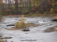
Waterfall Name: Sandy Creek Upper South Falls
Aka: ————-
Location: Ellisburg Twn
First Visit: 10-28-2007
State: New York State
Region: Northern Region
County: Jefferson County
Park Area: ————-
NYS Tourism Region: Thousand Island-Seaway
NYDEC Region: Western Adirondacks/Eastern Lake Ontario
Waterfall Challenge: ————-
Waterfall Location: N43.76491 W76.06536
Parking: N43.76223 W76.06708
Trailhead: ————-
Trail Name, Reference to: ————-
Stream, River: South Sandy Creek South
Height, Type: Small 3ft Falls
Elevation: 508 ft
Level of Difficulty, Hiking Distance: Roadside view
Whitewater Rte, Canoe Rte Map: ————-
Maps: http://www.worldwaterfalldatabase.com/waterfall/Upper-South-Sandy-Creek-Falls-9331/
My Resource: New York Atlas & Gazetteer Delorme Publication 2007 Pg 83 B6 Indicated by the word falls
Book Resource: ————-
Brochures, Travel Guides, Visitor Guides: ————-
Trail_URL: ————-
Additional Information: World Waterfalls Database
Photos, Information Contributed to other Websites: Dig the Falls
Landmark: Bridge
Nearest Intersection: Cr-85 and Wardwell Settlement Rd and Cr-91
Directions: From I-81 N in Ellisburg, Get on 40 and drive north .2 miles. Turn right onto Hwy 193 .7 miles. Turn left onto US 11 272 ft . Turn left onto Wardwell Settlement Rd and drive for 1.9 miles.
Comments, Notes: ————-
————-
————-
