
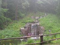
Waterfall Name: Trout Brook Falls, Chester Twn
Aka: Sawmill Falls
Location: Chester Twn
First Visit: 07-20-2008
State: New York State
Region: Northern Region
County: Warren County
Park Area: Natural Stone Bridge and Caves
NYS Tourism Region: Adirondack Mountains
NYDEC Region: Eastern Adirondacks/Lake Champlain
Waterfall Challenge: Adirondack Fifty Falls Challenge: A Guide to the Fifty Falls, by John Haywood, Russell Dunn,Warren,pg108
Waterfall Location: N43.74752 W73.85401
Parking: N43.74755 W73.85241
Trailhead: ————-
Trail Name, Reference to: ————-
Stream, River: Trout Brook
Height, Type: 8ft,Various
Elevation: 975 ft
Level of Difficulty, Hiking Distance: Moderate to Difficult
Whitewater Rte, Canoe Rte Map: ————-
Maps: ————-
My Resource: Eastern New York all outdoors Atlas and Field Guide Publication 2008,D5,pg111
Book Resource: Adirondack Waterfall Guide: New York’s Cool Cascades Paperback – September 1, 2003, by Russell Dunn,, C. Russell Dunn,III. Falls Along The Adirondack Northway, Adirondack Norway,pg180
Brochures, Travel Guides, Visitor Guides: http://stonebridgeandcaves.com/tour/map
Trail_URL: http://www.stonebridgeandcaves.com
Additional Information: ————-
Photos, Information Contributed to other Websites: ————-
Landmark: Stone Bridge And Caves Falls
Nearest Intersection: Natural Stone Bridge Rd
Directions: From I-87, heading south in Pottsville, get off at Exit 26. Turn right onto Stone Bridge Rd and drive 2.0 miles to the parking area. There will be signs indication this well known attraction.
Comments, Notes: ————-
————-
————-
