Mill Creek Falls on, Gomer Hill Rd – 3 Waterfalls

Mill Creek Falls on, Gomer Hill Rd – 3 Waterfalls

Mill Creek Falls on, Gomer Hill Rd – 3 Waterfalls

AKA:
—–
Location:
Turin Twn
First Visit:
6/7/2015
Region:
Northern
County:
Lewis
Park/Area:
—–
Gps of Falls:
N43.62570 W75.43184
Gps of Parking:
N43.62575 W75.43134
Gps of Trailhead:
—–
Trail Name/Reference to:
—–
Landmark:
Gomer Hill
Stream/River/Watershed:
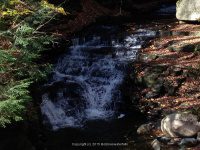
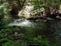
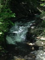
Mill Creek
Height of Falls/Type:
Step Ledges Various smaller falls
Elevation:
1575 ft – 1450 ft
Level of Difficulty/Hiking Distance:
Roadside
Wikiloc:
—–
Whitewater Rte/Canoe Rte Map:
—–
Maps:
—–
Trails Websites:
—–
My Resource:
Found this simply by being on the wrong road, another drive by.
Book Resource:
—–
Brochures/Travel Guides/Visitor Guides:
—–
Additional Information:
—–
Photos And Information I Contributed To or Posted To Other Websites:
—–
Nearest Intersection:
Gomer Hill Rd and Lyman Rd
Directions:
From the intersection of Hwy 26 and West Main St, in Turin, drive West on West Main St. At .5 miles you will come to a T intersection of West St and Co Rte 51. Turn left here and then an immediate right onto Gomer Hill Rd. At approximately .4 miles on your left is where we starting taking the photos of the various falls. Some are not significant, and we found the one fair size one. Follow Gomer Hill Rd up to where Mill Creek crosses under the road at the bridge.
Comments/Notes:
—–


Stone Valley Trail Waterfalls (10 Named Waterfalls and Dam)

Stone Valley Trail Waterfalls (10 Named Waterfalls and Dam)

Stone Valley Trail Waterfalls (10 Named Waterfalls and Dam)
Stone Valley Whitewater Route
St. Lawrence County, Colton Town

Stream or River: Raquette River flows into the St Lawrence River

Date Visited: 5/23/2015
 
The waterfalls along this trail in order are, Colton Dam, Colton Falls 5.0, Tannery Ledges IV, Mushroom Ledges III, The Narrows, The Tubs, Island Falls 5.0, 200 Proof IV, Lucy’s Hole, and O’malley Brook Falls
Resources Used:
Stone Valley Colton to Brown’s Bridge
Stone Valley Trail Map
The Stone Valley Cooperative Recreational Area
Eastern NY All Outdoors Atlas and Field Guide Publication 2008 pg 92 B1
World Waterfall Database

I Love New York, St Lawrence County Waterfalls Guide,
Explore Our Great Outdoors, St Lawrence County Chamber of Commerce.
Adirondack Great Walks & Day Hikes A Guide to paths less taken in the Northeast’s last great wilderness. You can download or request brochures here
Directions:
From US 11 and Highway 345 and Clarkson Avenue in Potsdam, Get on Maple Street and drive east for 23 ft. Turn right onto Clarkson Ave for 4.3 miles. Turn right onto Highway 56 and drive for 4.7 miles. Turn left onto Main Street and drive for .2 miles. Turn left onto Riverside Drive and drive for .2 miles. Which brings you to the parking area.
 Trail Description:
7.5 mile loop or 3.2 miles one-way, easy to moderate
Informational plaques are located at various points on the trails. Riverside trails are indicated by blue tree markers, access trails by dark red, and county trails by yellow markers.

For additional information click on the following links
Colton Dam

Colton Falls
Tannery Ledges
Mushroom Ledges
The Narrows aka Horseshoes Falls
The Tubs
Island Falls
Da-falls Left of Island “Particle Accelerator” Right of Island

200 Proof IV
Lucy’s Hole
O’malley Brook Falls

I have recorded the tracks for the and can be viewed and downloaded, click on the following link.
Wikiloc Stone Valley Trail

Powered by Wikiloc

Need some public help here

Need some public help here

Need some public help here
I am currently trying to get support on my website. The other day all of a sudden I cannot see anything on the home page, it comes up blank. I can edit the page but cannot see it. Can anyone do a test and go to website and tell me if you can see the home page. Home page meaning as the tab to see the list of the waterfalls. Please

I have to verify but I was for sure this was on the Independence River but Wikiloc is showing Otter Creek

I have to verify but I was for sure this was on the Independence River but Wikiloc is showing Otter Creek

I have to verify but I was for sure this was on the Independence River but Wikiloc is showing Otter Creek


This is private property

This is private property

This is private property

This one is private property

This one is private property

This one is private property

Another unknown at the moment

Another unknown at the moment

Another unknown at the moment

Eatonville

Eatonville

Eatonville
  

Unknown at moment

Unknown at moment

Unknown at moment

Whetstone

Whetstone

Whetstone
WHETSTONE WIKILOC TRAIL

Home » Whetstone » WHETSTONE GULF TRAIL START
Home » Whetstone » WHETSTONE GULF, FIRST SECTION
Home » Whetstone » WHETSTONE GULF, 2ND SECTION
Home » Whetstone » WHETSTONE GULF FALLS