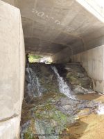
Waterfall Name: Unnamed Stream, falls on, Route 30 (Delaware)
Aka: ————-
Location: Roxbury Twn
First Visit: 08-10-2014
State: New York State
Region: Central Region
County: Delaware County
Park Area: ————-
NYS Tourism Region: Catskill Mountains
NYDEC Region: Capital Region/Northern Catskills
Waterfall Challenge:————-
Waterfall Location: N42.34035 W74.54320
Parking: N42.33994 W74.54472
Trailhead: ————-
Trail Name, Reference to: ————-
Stream, River: Unnamed Stream
Height, Type: ————-
Elevation: 1570 ft
Level of Difficulty, Hiking Distance: Roadside view
Whitewater Rte, Canoe Rte Map: ————-
Maps: ————-
My Resource: Drive by
Book Resource: ————-
Brochures, Travel Guides, Visitor Guides: ————-
Trail_URL: ————-
Additional Information: ————-
Photos, Information Contributed to other Websites: Dig the Falls
Landmark: ————-
Nearest Intersection: Hwy 30 and Mac More Rd
Directions: From the intersection of Hwy 30 and Hwy 23 in Grand Gorge, Get on Hwy 30 and drive southwest 3.2 miles.
Comments, Notes: Located under the road.
————-
————-
————-


