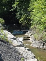
Waterfall Name: Frankfort Gorge, Falls #2
Aka: ————-
Location: Frankfort Twn
First Visit: 07-17-2016
State: New York State
Region: Central Region
County: Herkimer County
Park Area: Frankfort Gorge
NYS Tourism Region: Adirondack Mountains
NYDEC Region: Western Adirondacks/Eastern Lake Ontario
Waterfall Challenge:————-
Waterfall Location: N43.01782 W75.12514
Parking: ————-
Trailhead: ————-
Trail Name, Reference to: ————-
Stream, River: Moyer Creek
Height, Type: Several cascades along the Hwy 171
Elevation: 847 ft
Level of Difficulty, Hiking Distance: ————-
Whitewater Rte, Canoe Rte Map: ————-
Maps: ————-
My Resource: Seen this when I was in the area, and finally went back to check it all out.
Book Resource: ————-
Brochures, Travel Guides, Visitor Guides: ————-
Trail_URL: ————-
Additional Information: ————-
Photos, Information Contributed to other Websites: Dig the Falls
Landmark: ————-
Nearest Intersection: Hwy 171 and Furnace Rd
Directions: From the intersection of Hwy 5s and Hwy 171, Get on Hwy 171 and drive southwest for 2.4 miles. On your right you will see this first falls. Continue on Hwy 171 for another .4 miles. At some point along here you will have to find a safe parking and continue your walk up along side of the road. The other option is to park at the top of the hill and walk back down.
Comments, Notes: There are several small waterfalls and cascades along Hwy 171 (the Frankfort Gorge). I have only list the ones I have gotten to. Frankfort Gorge Cascades, #8 photo N43.01680 W75.11748, Frankfort Gorge Cascades, #9 photo N43.01740 W75.12491, Frankfort Gorge Cascades, #10, #11, #12 photo 2 N43.01801 W75.12615, Frankfort Gorge Cascades, #10, #11, #12 photo N43.01801 W75.12582, Frankfort Gorge Cascades, #13, #14 photo N43.01792 W75.12694
————-
————-


