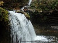
Waterfall Name: Van Hornsville Waterfalls – Creamery Falls
Aka: Van Hornsville Waterfalls
Location: Stark Twn
First Visit: 03-06-2010
State: New York State
Region: Central Region
County: Herkimer County
Park Area: Robert B Woodruff Outdoor Learning Center
NYS Tourism Region: Adirondack Mountains
NYDEC Region: Western Adirondacks/Eastern Lake Ontario
Waterfall Challenge:————-
Waterfall Location: N42.89809 W74.82186
Parking: N42.89659 W74.82559
Trailhead: ————-
Trail Name, Reference to: ————-
Stream, River: Creamery Creek
Height, Type: 50ft,Staircase Cascade
Elevation: 1068 ft
Level of Difficulty, Hiking Distance: Main Loop .64 Mile and Additional Side Trails .32 Miles
Whitewater Rte, Canoe Rte Map: ————-
Maps: ————-
My Resource: Mohawk Region Waterfall Guide: From the Capital District to Cooperstown & Syracuse: The Mohawak and Schoharie Valleys, Helderbergs, and Leatherstocking Country, Paperback – June 12, 2007, by Russell Dunn,Waterfalls Along Route 20,pg151
Book Resource: Mohawk Region Waterfall Guide: From the Capital District to Cooperstown & Syracuse: The Mohawak and Schoharie Valleys, Helderbergs, and Leatherstocking Country, Paperback – June 12, 2007, by Russell Dunn,Waterfalls Along Route 20,pg151
Brochures, Travel Guides, Visitor Guides: ————-
Trail_URL: ————-
Additional Information: Waterfalls of New York State Paperback – August 9, 2012, by Scott Ensminger, David Schryver, Edward Smathers,Capital Region,pg26
Photos, Information Contributed to other Websites: ————-
Landmark: Above the Main Falls Marker 6 & 7
Nearest Intersection: Rte 80 and Wiltse Hill Rd
Directions: From I-90 E, in Canajoharie, Take exit 29 to the right towards Rt-10/Canajoharie/Sharon Springs and drive for .5 miles.Turn right onto E Main St and drive for 3.6 miles. Turn left onto Main St and drive for .2 miles. Turn right onto Main St and drive for 11.5 miles. Turn left onto Tilyou Rd for 187 ft.
Comments, Notes: Marker number 6 is marked for the caves but also there is marker number 7 for Creamery Falls.
————-
————-


