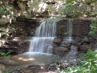
Waterfall Name: Canastota Falls
Aka: Falls On The North Country Trail/link Trail
Location: Lincoln Twn
First Visit: 07-24-2014
State: New York State
Region: Central Region
County: Madison County
Park Area: North Country Link Trail
NYS Tourism Region: Central Leatherstocking
NYDEC Region: Central New York
Waterfall Challenge:————-
Waterfall Location: N43.04340 W75.75657
Parking: N43.05875 W75.74943
Trailhead: ————-
Trail Name, Reference to: North Country Trail/link Trail
Stream, River: Canastota Creek
Height, Type: Drop
Elevation: 675 ft
Level of Difficulty, Hiking Distance: From nelson road to Canastota Falls is .6 mile round trip. The total approximate distance from the parking on Oxbow Road and following the trail to Nelson Road it is 1.7 miles one way.
Whitewater Rte, Canoe Rte Map: ————-
Maps: https://www.madisoncounty.ny.gov/planning/trails
My Resource: Madison County Trails
Book Resource: ————-
Brochures, Travel Guides, Visitor Guides: https://www.madisoncounty.ny.gov/planning/trails
Trail_URL: ————-
Additional Information: ————-
Photos, Information Contributed to other Websites: Dig the Falls
Landmark: ————-
Nearest Intersection: Cottons Rd and Nelson Rd
Directions: From I-90 W, in Canastota, Take exit 34 to the right onto Rt-13 towards Canastota/Chittenango and drive for 2.9 miles. Madison Link Trail Parking 1 Get on Oxbow Rd and drive south and drive for 1.2 miles. Turn right onto Cottons Rd and drive for .9 miles. Turn right onto Nelson Rd and drive for .3 miles. Madison Link Trail Parking 2
Comments, Notes: This was very easy to find. The trail looks well maintained. I have included a picture of the area where you would have to turn off main trail. Just listen for the falls. This section of the trail has the two seasonal waterfalls. More looks like run offs from somewhere further up. Also on this same section is the canastota falls and dam.
————-
————-
————-


