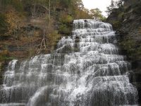
Waterfall Name: Hector Middle Falls
Aka: Hector Falls Lower #1
Location: Hector Twn
First Visit: 10-19-2010
State: New York State
Region: Central Region
County: Schuyler County
Park Area: ————-
NYS Tourism Region: Finger Lakes-Wine Country
NYDEC Region: Western Finger Lakes
Waterfall Challenge:————-
Waterfall Location: N42.41799 W76.86757
Parking: N42.419017 W76.866938
Trailhead: N42.419017 W76.866938
Trail Name, Reference to: ————-
Stream, River: Logan Creek
Height, Type: 165ft total,Cascade
Elevation: 499 ft
Level of Difficulty, Hiking Distance: Roadside View/ttp://home.htva.net/~goldenknightinn/finger_lake_waterfall_resort.htm
Whitewater Rte, Canoe Rte Map: ————-
Maps: Western New York All-Outdoors Atlas & Field Guide, 2008,C2,pg102
My Resource: http://home.htva.net/~goldenknightinn/finger_lake_waterfall_resort.htm
Book Resource: 200 Waterfalls in Central and Western New York: A Finder’s Guide Paperback – June 5, 2018, by Rich and Sue Freeman,Waterfalls in Schuyler and Tompkins Counties,pg282
Brochures, Travel Guides, Visitor Guides: ————-
Trail_URL: ————-
Additional Information: World Waterfall Database
Photos, Information Contributed to other Websites: ————-
Landmark: Sign Before Bridge, Hector Falls Point
Nearest Intersection: Highway 414 and S Falls Rd
Directions: From I-90 W, Take exit 42 to the right onto Rt-14 towards Geneva/Lyons and drive for .7 miles. Take the Rt-14 S ramp to the right towards Rt-96/Geneva/Clifton Springs and drive for 3.1 miles. Turn left onto Packwood Rd and drive for 3.2 miles. Turn right onto Waterloo Geneva Rd and drive for 1.7 miles. Turn left onto Hwy 96a and drive for 3.0 miles. Keep right onto Hwy 96a and drive for 2.9 miles. Keep right onto Hwy 96a and drive for 9.1 miles. Keep right onto Cr-132a and drive for 5.5 miles. Turn right onto Upper Lake Rd and drive for 1.8 miles. Turn right onto Hwy 414 and drive for 4.2 miles. Keep right onto Hwy 414 and drive for 8.1 miles.
Comments, Notes: ————-
————-
————-
————-

