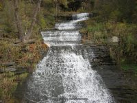
Waterfall Name: Johns Creek Lower Falls
Aka: Johns Creek Glen, Johns Creek Falls
Location: Montour Twn
First Visit: 10-19-2010
State: New York State
Region: Central Region
County: Schuyler County
Park Area: ————-
NYS Tourism Region: Finger Lakes-Wine Country
NYDEC Region: Western Finger Lakes
Waterfall Challenge:————-
Waterfall Location: N42.35534 W76.83621
Parking: N42.355383 W76.836884
Trailhead: N42.355383 W76.836884
Trail Name, Reference to: ————-
Stream, River: Johns Creek
Height, Type: Cascade
Elevation: 525 ft
Level of Difficulty, Hiking Distance: Roadside views
Whitewater Rte, Canoe Rte Map: ————-
Maps: ————-
My Resource: I found this looking for havana glen park. Resources tells me this is the proper name
Book Resource: ————-
Brochures, Travel Guides, Visitor Guides: ————-
Trail_URL: ————-
Additional Information: World Waterfall Database
Photos, Information Contributed to other Websites: ————-
Landmark: ————-
Nearest Intersection: Rock Cabin Rd and N Lhommedieu
Directions: From I-90 W, near Magee, Take exit 41 to the right onto Rt-414 towards Waterloo/Clyde and drive for .8 miles. Take the Rt-414 S ramp to the right towards US-20/Rt-5/Waterloo/Seneca Falls and drive for 4.5 miles. Turn right onto E River Rd and drive for 1.4 miles. Turn left onto Fayette St and drive for 26.9 miles. Keep right onto Hwy 414 and drive for 7 miles. Turn left onto Tug Hollow Rd and drive for 1.1 miles. Turn left onto Lake St for 411 ft. Turn right onto Willow St and drive for .8 miles. Turn left onto Cr-9 and drive for 4 miles.
Comments, Notes: ————-
————-
————-
————-

