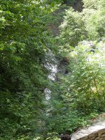
Waterfall Name: Sylvan Rapids in Watkins Glen
Aka: ————-
Location: Watkins Glen
First Visit: 06-13-1991
State: New York State
Region: Central Region
County: Schuyler County
Park Area: Watkins Glen State Park
NYS Tourism Region: Finger Lakes-Wine Country
NYDEC Region: Western Finger Lakes
Waterfall Challenge:————-
Waterfall Location: N42.37400 W76.87884
Parking: N42.375608 W76.872117
Trailhead: N42.375131 W76.873687
Trail Name, Reference to: The Gorge Trail, Upper Park Trailhead N42.372783 W76.891666, starts out on the Indian Trail and connects to the Gorge Trail
Stream, River: Glen Creek
Height, Type: 13ft Rapids
Elevation: 796 ft
Level of Difficulty, Hiking Distance: approx. .5 to .6 miles one way
Whitewater Rte, Canoe Rte Map: ————-
Maps: ————-
My Resource: Nyfalls Falzguy
Book Resource: ————-
Brochures, Travel Guides, Visitor Guides: Finger Lakes Tourism Alliance website
Trail_URL: Watkins Glen Trail Map
Additional Information: ————-
Photos, Information Contributed to other Websites: ————-
Landmark: This Is In The Section Known As Glen Cathedral, near the Lover’s Lane trail
Nearest Intersection: Highway 14 (Franklin Stree) and 10th Street
Directions: From I-90 W , Take exit 42 to the right onto Rt-14 towards Geneva/Lyons and drive for .7 miles. Take the Rt-14 S ramp to the right towards Rt-96/Geneva/Clifton Springs and drive for 5.8 miles. Turn right onto Castle St and drive for .2 miles. Turn left onto Main St and drive for 35.8 miles.
Comments, Notes: ————-
————-
————-
————-

