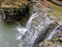
Waterfall Name: Templer Upper Falls (Dix)
Aka: Twin Falls
Location: Dix Twn
First Visit: 10-19-2010
State: New York State
Region: Central Region
County: Schuyler County
Park Area: Van Zandt Hollow
NYS Tourism Region: Finger Lakes-Wine Country
NYDEC Region: Western Finger Lakes
Waterfall Challenge:Finger Lakes Region Waterfall Challenge Paperback – October 30, 2019, by John Haywood, Julie Hughes Romano, Bella Romano, Edward Smathers,Schuyler,pg58
Waterfall Location: N42.3686 W76.95889
Parking: N42.36850 W76.95814
Trailhead: N42.36850 W76.95814
Trail Name, Reference to: ————-
Stream, River: Glen Creek
Height, Type: 15ft Upper 10ft Lower Cascade
Elevation: 1275 ft
Level of Difficulty, Hiking Distance: FLT Map M14TF/.03 Miles
Whitewater Rte, Canoe Rte Map: ————-
Maps: Western New York All-Outdoors Atlas & Field Guide, 2008,D1,pg102
My Resource: Western New York All-Outdoors Atlas & Field Guide, 2008,D1,pg102
Book Resource: 200 Waterfalls in Central and Western New York: A Finder’s Guide Paperback – June 5, 2018, by Rich and Sue Freeman,Waterfalls in Schuyler and Tompkins Counties,pg290
Brochures, Travel Guides, Visitor Guides: ————-
Trail_URL: ————-
Additional Information: World Waterfall Database
Photos, Information Contributed to other Websites: ————-
Landmark: Trail Ebenezers Crossing
Nearest Intersection: Templar Rd and Van Zandt Hollow Rd
Directions: From I-90 W , Take exit 42 to the right onto Rt-14 towards Geneva/Lyons and drive for .7 miles. Take the Rt-14 S ramp to the right towards Rt-96/Geneva/Clifton Springs and drive for 5.8 miles. Turn right onto Castle St and drive for .2 miles. Turn left onto Main St and drive for 19.7 miles. Turn right onto Plum Point Rd and drive for .6 miles. Turn left onto Lakemont Himrod Rd and drive for .9 miles. Turn right onto Dundee Himrod Rd and drive for 8.5 miles. Turn right onto Hwy 226 and drive for .2 miles. Turn left onto Cr-27 and drive for 4.1 miles. Turn left onto Mud Lake Hammondsport Rd and drive for .7 miles. Turn right onto Cross Rd and drive for 1.7 miles. Turn right onto Vanzandt Hollow Rd and drive for .5 miles.
Comments, Notes: Just follow the trail a short distance to the falls. You will have to cross the creek to get to the trail on the other side. Use caution when getting to the bottom.
————-
————-
————-


