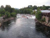
Waterfall Name: Anderson Falls
Aka: Keeseville Falls
Location: Keeseville
First Visit: 08-18-2008
State: New York State
Region: Northern Region
County: Clinton County
Park Area: ————-
NYS Tourism Region: Adirondack Mountains
NYDEC Region: Eastern Adirondacks/Lake Champlain
Waterfall Challenge: Adirondack Fifty Falls Challenge: A Guide to the Fifty Falls, by John Haywood, Russell Dunn,Essex
Waterfall Location: N44.50383 W73.48181
Parking: N44.50485 W73.47997
Trailhead: ————-
Trail Name, Reference to: ————-
Stream, River: Ausable River
Height, Type: 15ft waterslides and cascades
Elevation: 409 ft
Level of Difficulty, Hiking Distance: Roadside view
Whitewater Rte, Canoe Rte Map: ————-
Maps: ————-
My Resource: Anderson Falls Heritage Society Of Keeseville
Book Resource: Keene Valley Region Waterfall Guide: The Search for Cool Cascades in the Heart of the Adirondacks Paperback – November 10, 2017, by C. Russell Dunn,Section VII: From Keene to Keeseville,pg151
Brochures, Travel Guides, Visitor Guides: ————-
Trail_URL: ————-
Additional Information: ————-
Photos, Information Contributed to other Websites: Dig the Falls
Landmark: Keeseville Library
Nearest Intersection: US 9 and Front Street and Main Street
Directions: From I-87 N in Keeseville, Take exit 34 to the right onto Rt-9n towards Ausable Forks/Keeseville and drive for .3 miles. Turn right onto Hwy 9n and drive for 1.1 miles. Turn right onto Main St and drive for .2 miles. Turn right onto Front St 260 ft. Turn right onto Mill St and find parking.
Comments, Notes: ————-
————-
————-


