
Waterfall Name: Ausable Chasm – Dam And Falls
Aka: ————-
Location: Chesterfield Twn
First Visit: 08-17-2008
State: New York State
Region: Northern Region
County: Clinton County
Park Area: Ausable Chasm
NYS Tourism Region: Adirondack Mountains
NYDEC Region: Eastern Adirondacks/Lake Champlain
Waterfall Challenge: ————-
Waterfall Location: N44.52344 W73.46011
Parking: N44.52530 W73.46253
Trailhead: N44.524252 W73.460991
Trail Name, Reference to: ————-
Stream, River: Ausable River
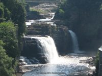
Height, Type: 15ft ledges,dam
Elevation: 275 ft
Level of Difficulty, Hiking Distance: Short easy walk on side walk
Whitewater Rte, Canoe Rte Map: http://www.americanwhitewater.org/content/River/detail/id/1236/
Maps: ————-
My Resource: Adirondack Waterfall Guide “New York’s Cool Cascades” By Russell Dunn 2004
Book Resource: Keene Valley Region Waterfall Guide: The Search for Cool Cascades in the Heart of the Adirondacks Paperback – November 10, 2017, by C. Russell Dunn,Section VII: From Keene to Keeseville,pg156
Brochures, Travel Guides, Visitor Guides: Adirondack Great Walks & Day Hikes A Guide to paths less taken in the Northeast’s last great wilderness.
Trail_URL: ————-
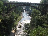
Additional Information: Ausable Chasm Grand Canyon of the Adirondacks
Photos, Information Contributed to other Websites: Northern New York Waterfalls
Landmark: Hydroelectric power house
Nearest Intersection: Rte 9 and Old State Rd
Directions: From I-87 N in Keeseville, Take exit 34 to the right onto Rt-9n towards Ausable Forks/Keeseville for .3 miles. Turn right onto Hwy 9n and drive for 1.3 miles. Turn left onto US 9 and drive for 1.5 miles.
Comments, Notes: The Dam and falls above Rainbow Falls. I had previously called this Middle and Upper Falls. If I remember correctly, there was a pathway that led from the back of the gift shop and snack bar to this area for viewing.
DAM AND FALLS at AUSABLE CHASM


————-
————-
