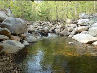
Waterfall Name: Jimmy Creek West Falls
Aka: ————-
Location: Wells Twn
First Visit: 05-10-2015
State: New York State
Region: Northern Region
County: Hamilton County
Park Area: ————-
NYS Tourism Region: Adirondack Mountains
NYDEC Region: Eastern Adirondacks/Lake Champlain
Waterfall Challenge: ————-
Waterfall Location: N43.37279 W74.35751
Parking: N43.36651 W74.34893
Trailhead: ————-
Trail Name, Reference to: ————-
Stream, River: West Jimmy Creek
Height, Type: 40ft,Lower rocky flume is .4 miles from West River Road
Elevation: 1449 ft
Level of Difficulty, Hiking Distance: .7 mile 1-way, .4 miles to lower
Whitewater Rte, Canoe Rte Map: ————-
Maps: ————-
My Resource: Discover the Southern Adirondacks, Walks, Waterways, Old Roads & Open Peaks, 5th Edition 2014, Bill Ingersoll pg 280-281 trail 136
Book Resource: ————-
Brochures, Travel Guides, Visitor Guides: ————-
Trail_URL: ————-
Additional Information: World Waterfalls Database
Photos, Information Contributed to other Websites: ————-
Landmark: West River Road overnight camping
Nearest Intersection: West River Rd and Town Rd
Directions: From the intersection of Hwy 30 and Buttermilk Hill Rd in Wells take Hwy 30 south for .4 miles. Turn right on Algonquin Drive for .7 miles. Turn left onto West River Rd and drive for 3.4 miles. The falls will be on your right directly across from a fishing area. Just a little further down the road is a designated overnight camping spot.
Comments, Notes: There was not much water running when we visited here. Further information states the actual falls is further upstream. Plans to return in the future.
————-
————-

