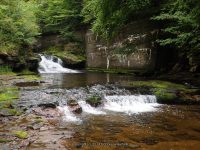
Waterfall Name: Beaverkill Falls (Liberty Town)
Aka: ————-
Location: Liberty Twn
First Visit: 08-23-2014
State: New York State
Region: Southern Region
County: Sullivan County
Park Area: ————-
NYS Tourism Region: Catskill Mountains
NYDEC Region: Lower Hudson Valley
Waterfall Challenge: ————-
Waterfall Location: N41.85852 W74.76580
Parking: N41.85895 W74.76460
Trailhead: ————-
Trail Name, Reference to: ————-
Stream, River: Little Beaver Kill
Height, Type: ————-
Elevation: 1650 ft
Level of Difficulty, Hiking Distance: Short Scramble
Whitewater Rte, Canoe Rte Map: ————-
Maps: ————-
My Resource: World Waterfall Database.
Book Resource: ————-
Brochures, Travel Guides, Visitor Guides: ————-
Trail_URL: ————-
Additional Information: ————-
Photos, Information Contributed to other Websites: Dig the Falls
Landmark: Rest Area With A Couple Of Picnic Tables
Nearest Intersection: Highway 17 and Breezy Hill Rd
Directions: From I-87 S near Kingston, Take exit 19 to the right towards Rt-28/Kingston/Rhinecliff Br and drive for .7 miles. Keep right onto Rt-28 W towards US-209/Ellenville/Rhinecliff Br and drive for .6 miles.Take the US-209 S ramp to the right towards Ellenville and drive for 26.9 miles. Turn right onto Canal St and drive for 19.3 miles. Keep right onto Triangle Rd and drive for .2 miles. Take the Rt-17 W ramp and drive for 4.8 miles. Take exit 98 to the right towards Parksville and drive for .3 miles. Turn right onto Short Ave and drive for .2 miles. Turn left onto Parksville Rd and drive for .4 miles.
Comments, Notes: There is a small rest area with picnic tables. You will find the small trail fairly easy almost straight back from picnic tables.
————-
————-
————-


