Stone Valley Trail Waterfalls (10 Named Waterfalls and Dam)
Stone Valley Trail Waterfalls (10 Named Waterfalls and Dam)
Stone Valley Whitewater Route
St. Lawrence County, Colton Town
Stream or River: Raquette River flows into the St Lawrence River
Date Visited: 5/23/2015
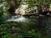
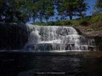
The waterfalls along this trail in order are, Colton Dam, Colton Falls 5.0, Tannery Ledges IV, Mushroom Ledges III, The Narrows, The Tubs, Island Falls 5.0, 200 Proof IV, Lucy’s Hole, and O’malley Brook Falls
Resources Used:
Stone Valley Colton to Brown’s Bridge
Stone Valley Trail Map
The Stone Valley Cooperative Recreational Area
Eastern NY All Outdoors Atlas and Field Guide Publication 2008 pg 92 B1
World Waterfall Database
I Love New York, St Lawrence County Waterfalls Guide,
Explore Our Great Outdoors, St Lawrence County Chamber of Commerce.
Adirondack Great Walks & Day Hikes A Guide to paths less taken in the Northeast’s last great wilderness. You can download or request brochures here
Directions:
From US 11 and Highway 345 and Clarkson Avenue in Potsdam, Get on Maple Street and drive east for 23 ft. Turn right onto Clarkson Ave for 4.3 miles. Turn right onto Highway 56 and drive for 4.7 miles. Turn left onto Main Street and drive for .2 miles. Turn left onto Riverside Drive and drive for .2 miles. Which brings you to the parking area.
Trail Description:
7.5 mile loop or 3.2 miles one-way, easy to moderate
Informational plaques are located at various points on the trails. Riverside trails are indicated by blue tree markers, access trails by dark red, and county trails by yellow markers.
For additional information click on the following links
Colton Dam
Colton Falls
Tannery Ledges
Mushroom Ledges
The Narrows aka Horseshoes Falls
The Tubs
Island Falls
Da-falls Left of Island “Particle Accelerator” Right of Island
200 Proof IV
Lucy’s Hole
O’malley Brook Falls
I have recorded the tracks for the and can be viewed and downloaded, click on the following link.
Wikiloc Stone Valley Trail