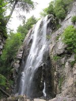
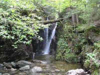
St. Huberts Area (6 Main Waterfalls and several others)
St. Huberts Area (6 Main Waterfalls and several others), Essex County, Keene Town
Date Visited: 8/11/2011
Resources Used:
Eastern NY All Outdoors Atlas and Field Guide Publication 2008 pg 103 D6
Adirondack Waterfall Guide “New York’s Cool Cascades” By Russell Dunn
World Waterfall Database
Adirondack Waterways A Guide to paddling routes in the Northeast’s last great wilderness. You can download or request brochures here
Trail Description:
East River Trail and West River Trail
It is approximately a 10 mile loop. The trail can be difficult and muddy, please use caution. Give yourself plenty of time, along with food and water. Be sure to carry along all necessary items, such as first aid kits, flashlights etc.
Nearest Intersection:
St Huberts Road And Ausable Club Road And Lake Road
Directions:
From I-87 N in North Hudson, Take exit 30 to the right onto US-9 towards Rt-73/Keene Valley/Keene and drive for .2 miles. Turn left onto US 9 and drive for 2.2 miles. Keep left onto Hwy 73 N and drive for 5.4 miles. Turn left onto Ausable Rd and drive for .2 miles to the parking area.
Note:
This is a re-construction of the hike. At the time of my visit, I did not use tracking devices. Distance does not included some of the spur trails. This is to the best of my ability.
Points of reference, time and mileage included as close as possible.
Arrived a parking area at 8:25 am
Ausable Club Rd Parking
N44.14903 W73.77027 1282 ft
Arrived at the gate and sign in at 8:53 am (.5 mile walk down Ausable Club Road)
St Huberts Rd and Ausable Club Rd and Lake Rd Parking
N44.15066 W73.77899
Crossed over a wooden footbridge at 8:57 am (.3 miles) We are now .8 miles into the hike.
Trail sign for WA White trail Lower Wolfjaw Snow Mtn and Roostercomb N44.15010 W73.78399 1305 ft
Crossed over a wooden footbridge at 9:10 am (.3 miles) We are now 1.1 miles into the hike.
First trail sign for bear run Cathedral Rocks and Pyramid Brook
N44.14678 W73.78884 1360 ft
Arrived at trail for Pyramid Brook at 9:38 am (.6 miles) We are now 1.7 miles into the hike.
Second trail sign for direct route to pyramid brook near falls and Cathedral Rock N44.14290 W73.79918 1524 ft
Arrived at trail for Wedge Brook Cascades at 10:58 am (.8 miles) We are now 2.5 miles into the hike.
Wedge Brook Cascades Sign for Wedge Brook Cascades 200 yards, Wolfjaw, and Beaver Meadow Falls Lower Lake
N44.13561 W73.81070
Arrived at Beaver Meadow Falls and crossed another wooden bridge about 11:38 am (.6 miles) We are now 3.1 miles into the hike.
Beaver Meadow Falls E Branch Ausable River
N44.12906 W73.81573 1912 ft
Trail sign for Gothic and Armstrong
N44.12867 W73.81684 1923 ft
Arrived at trail sign for Rainbow Falls at 11:41 am (.8 miles) We are now 3.9 miles into the hike.
Trail sign for Gothics and Armstrong, west river trail and lower lake, and Rainbow Falls N44.11862 W73.82529 1954 ft
Trail sign for Alfred w weld trail to gothics, rainbow falls
N44.11861 W73.82641 2030 ft
Arrived at Rainbow Falls at about 12:36 pm
Rainbow Falls N44.11860 W73.82589
Trail sign for Indian Head Fishhawk Cliffs and Colvin
N44.11756 W73.82409 2018 ft
Trail Sign for Indian Head Fishhawk Cliffs
N44.11410 W73.82202 2525 ft
Arrived at Fishhawk Cliffs at about 2:16 pm (.7 miles) We are now about 4.6 miles into the hike.
Trail sign for Indian Head, and Gothic Window 117 feet
N44.11028 W73.82390 2497 ft
Trail sign for road, Indian head, colvin, nipple top, fishhawk cliffs and Elk Pass .4 miles N44.11065 W73.81628 2442 ft
Trail sign for road and gill brook trail, Indian head, colvin, nipple top, fishhawk cliffs .3 miles
N44.11506 W73.81522 2283 ft
We are now at the start of the falls along Gill Brook 2:47 pm and at about 5.3 miles into the hike. From this point along Gill Brook Trail to Lake Road is another 1.2 miles giving it at 6.5 miles
Gill Brook Falls 9 10 ft Gill Brook
N44.11999 W73.81125 2101 ft
Gill Brook Falls 8 Long Slide Gill Brook
N44.12080 W73.81075 2071 ft
Gill Brook Falls 7 Flume Gill Brook
N44.12148 W73.81035 2055 ft
Gill Brook Falls 6 25 ft Gill Brook
N44.12198 W73.81019 2026 ft
Gill Brook Falls 5 9 ft Cascade Gill Brook
N44.12247 W73.81003 1994 ft
Gill Brook Falls 4 15 ft Flume Gill Brook
N44.12293 W73.80988 1972 ft
Gill Brook Falls 2 Chute Gill Brook
N44.12397 W73.80948 1918 ft
From this Trail sign at the end of the Gill Brook Trail (or the beginning) and back to the parking area is an additional 2.6 miles giving a total of about 9.1 miles.
Trail sign for gill brook trail, gill brook colvin indian head Lake Rd
N44.12967 W73.80676 1701 ft

