Deckertown Falls
Deckertown Falls, Schuyler County, New York


Deckertown Falls, Schuyler County, New York

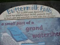
Buttermilk Falls State Park – 8 Named Waterfalls, Ithaca
Buttermilk Falls State Park, Tompkins County, Ithaca, New York
Stream or River: Buttermilk Creek flows into Cayuga Lake
There are several falls of varying heights and types. Other named waterfalls here are: Pulpit Falls, Shower Bath Falls and Pinnacle Falls.
Dates Visited:
5/06/2012 7/15/2006 9/02/2006
I have yet to see all the falls here in the park. We only made it maybe to the top of the Main Falls due to it was really pouring rain that day. I wanted to include all the information I have accumulated since 2006. If the information I provided here is different or wrong, or you have additional information to provide, feel free to let me know.
Maps and Resources used to gather information:
Western New York all outdoors Atlas & Field Guide Publication 2008 103 C6
200 Waterfalls In Central & Western New York “A Finders’ Guide” By Rich And Sue Freeman 2002
New York Waterfalls “A Guide For Hikers & Photographers” by Scott E. Brown 2010
http://nyfalls.com/waterfalls/buttermilk-falls-state-park/
World Waterfall Database
Directions:
From I-81 S, in Whitney Point, Take exit 8 to the right onto Rt-79/US-11 towards Rt-26/Rt-206/Whitney Point/Lisle and drive .3 miles. Turn right onto US 11 and drive 29.5 miles. Keep left onto E State Street and drive .1 miles. Turn left onto S Aurora Street and drive .1 miles. Turn right onto Prospect Street for 252 ft. Bear left onto Prospect Street for 424 ft. Bear left onto E Spencer Street and drive .2 miles. Turn left onto S Cayuga Street for 165 ft. Keep right onto W Spencer Street and drive .2 miles. Enter roundabout Roundabout for 147 ft. Take the 2nd right onto Elmira Road and drive .4 miles. Bear right onto Elmira Road for 103 ft. Turn left onto Elmira Road and drive 1.1 miles. Turn left onto Buttermilk Falls Road E and drive .1 miles.
Length of Hike:
Gorge Trail: 0.75 miles. Strenuous
Rim Trail: 0.75 miles Strenuous
Bear Trail: 0.5 miles. Moderate
Lake Treman: 1.5 miles. Easy
Parking areas:
Parking N42.41718 W76.52123
Upper Parking Rd N42.40935 W76.51213
Upper Parking Rd 2 N42.40166 W76.51393
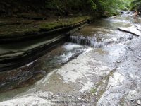
Buttermilk Creek And Falls aka Main Falls
Lower and Upper section has the viewing platform in the middle.
Falls: N42.41599 W76.52045
Height: 180 ft
Elevation: 450 ft
Type: Cascade


Pinnacle Falls in Buttermilk Falls State Park
Falls: N42.41111 W76.51654
Landmark: Pinnacle Rock
Height: 30 ft
Elevation: 833 ft
Type: 2 steps
Pulpit Falls in Buttermilk Falls State Park
Falls: N42 26.004 W76 29.100
Landmark: Pulpit Rock above the falls
Elevation: 750 ft
Type: 2 tiered
Shower Bath Falls in Buttermilk Falls State Park
Falls: N42.41060 W76.51509
Landmark: above Pinnacle Rock
Elevation: 850 ft
Lake Treman Falls
Falls: N42.40050 W76.51276
Owl Creek Falls
Falls: N42.41174 W76.51006
Height: 70 ft
Type: Steep Cascade
Starting from Highway 13 Buttermilk Falls Entrance North to South and parking areas
Waterfall Location Elevation
1 Buttermilk Creek Dam N42.41633 W76.52130 452 ft
2 Buttermilk Lower Falls N42.41599 W76.52045
3 Buttermilk Upper Falls N42.41507 W76.51953 610 ft
4 Waterfall in N42.41447 W76.51911 672 ft
5 Waterfall 1 N42.41365 W76.51854 741 ft
6 Waterfall 2 N42.41333 W76.51828 752 ft
7 Pulpit Falls N42.41303 W76.51804 778 ft
8 Buttermilk Creek bridge N42.41190 W76.51731 800 ft
9 Pinnacle Falls N42.41111 W76.51654 833 ft
10 Waterfall 3 N42.41070 W76.51544 846 ft
11 Shower Bath Falls N42.41060 W76.51509 850 ft
12 Flume Falls N42.41033 W76.51441 870 ft
13 Buttermilk Creek falls on N42.40892 W76.51263 874 ft
14 Buttermilk Creek falls on 2 N42.40273 W76.51101 904 ft
15 Lake Treman Falls N42.40065 W76.51291 951 ft
16 Owl Creek Falls N42.41162 W76.51002 873 ft
Welcome
Bobbieswaterfalls contains a listing of waterfalls that I have personally been to. Nothing more! This website is something I created as a personal goal of mine. I not only cover New York State, but have other states as well. These other states will be listed as soon as I can.
I have comprised counties group by how I visit each region. I have Northern Region, Eastern Region, Western Region, Central Region and Southern Region. Within each region I have the counties. You can also click on the individual counties if you wish to.
I have recently transitioned over to this new website. There is still a lot of work to do here. I have started this website working with my most recent activities and working backwards in years.
Along with the waterfalls, I have included dams and rapids. I am in hopes that down the road I will set the site up and have then in a separate listing.
I have a resource page started and will continue adding more.
I generally have destinations in mind and will set up road trips and cover a lot of miles. Sometimes I come back with not much luck and other times come back with alot to share. My goal each year is to find at least 30 waterfalls. Some years it happens and other years I have hit my goals and more so. My blog posts is usually done by roadtrips. Starting point to ending points. I will be starting that soon.
Again, I will also be listing waterfalls from other states. Seeing as I am from New York State, I am starting here first.
So feel free to check back often!
If there are any errors, feel free to contact me. The photos are all unedited and are as is. The information provided is to the best of my ability. I am not a professional photographer. I do some research on locations, but mostly it is enough for me to find the waterfall. If you are looking for more detailed information on waterfalls, check out the resource page. There is a lot of good information and writeups there.
The people and children you may see in some of the photos are my children, my grandchildren and friends and families. I started doing all this when my children were young and now have the pleasure of doing the same with my grandchildren. Gives me good reason to revisit some of the locations.

Stony Brook Glen Falls, Steuben County, New York State
More information about the Stony Brook Campground and trails can be found on their website.

Delaware Wild Forest, Russell Brook – 2 Waterfalls
Location: |
Colchester Twn |
First Visit: |
8/10/2014 |
Region: |
Central |
County: |
Delaware |
Park/Area: |
Delaware Wild Forest |
Gps of Falls: |
N41.99573 W74.93966 |
Gps of Parking: |
N41.99412 W74.94092 |
Landmark: |
Mud Pond & Trout Pond Hiking Trail and Campgrounds |
Stream/River/Watershed: |
Russell Brook |
Height of Falls/Type: |
30 ft, 10 ft |
Elevation: |
1800 ft |
Level of Difficulty/Hiking Distance: |
.1 Miles |
My Resource: |
Eastern New York all outdoors Atlas & Field Guide Publication 2008 |
Book Resource: |
Catskill Region Waterfall Guide “Cool Cascades Of The Catskills & Shawangunks” By Russell Dunn 2004 |
Additional Information: |
World Waterfall Database |
Nearest Intersection: |
Russell Brook Rd And Morton Rd |
Directions: |
From Hwy 17 W in Roscoe, Take exit 94 to the right towards Rt-206/Roscoe/Walton. Turn left onto Old Rt-17 and drive for .5 miles. Turn left onto Old Rt-17 and drive for 2 miles. Turn right onto Horse Brook Rd and drive for 2 miles. Turn left onto Morton Hill Rd and drive for 1.6 miles. |
Comments/Notes: |
When you are parked, the trail information will be to the left. Take the trail to the right of the sign and go right down the short trail. The trail to the bridge is very easy. Cross the bridge and follow the trail to the right again. You will see a small trail off to the right that leads to the base of the falls. For the upper view of the falls park on the roadside before you get to the actual parking area. Use extreme caution when viewing from the topside |
For additional information please click on the following links:
Russell Brook Falls
Russell Brook Upper Falls

Stockbridge Falls – 3 Waterfalls, Madison County, New York
AKA: |
Oneida Falls |
Location: |
Stockbridge Twn |
First Visit: |
10/20/2006 |
Region: |
Central |
County: |
Madison |
Gps of Falls: |
N42.95130 W75.60810 |
Gps of Parking: |
N42.95156 W75.60731 |
Landmark: |
Guardrails On Both Sides Of The Road |
Stream/River/Watershed: |
Oneida Creek |
Height of Falls/Type: |
100 ft Total 8 ft Lower, Cascade |
Elevation: |
950-825 ft |
Level of Difficulty/Hiking Distance: |
Roadside |
Maps: |
Delorme Atlas & Gazetteer New York State 9th Edition 2011 |
My Resource: |
Eastern New York all outdoors Atlas & Field Guide Publication 2008 |
Book Resource: |
Mohawk Region Waterfall Guide “From the Capital District to Cooperstown & Syracuse” By Russell Dunn 2007 |
Photos And Information I Contributed To or Posted To Other Websites: |
Digthefalls |
Nearest Intersection: |
Stockbridge Falls Rd and Falls Rd |
Directions: |
From I-90 W, in Verona, Take exit 33 to the right onto Rt-365 towards Verona/Oneida and drive for .9 miles. Keep left onto Rd ramp and drive for .2 miles. Turn left onto Hwy 365 W and drive for 3.8 miles. Turn right onto Seneca Ave and drive for .4 miles. Turn left onto Glenwood Ave and drive for 8.4 miles. Turn right onto Pratts Rd and drive for .6 miles. Turn right onto Stockbridge Falls Rd and drive for .8 miles. Turn left onto Falls Rd and drive for .1 miles. |
Comments/Notes: |
There is room for parking before the small bridge. There is private property on both sides of the falls. The 8 ft Lower Falls is located across the road from the Main Falls. There is a trail on the left side from the road. |
For additional information click on the following links:
Stockbridge Upper Falls
Stockbridge Middle Falls
Stockbridge Lower Falls

Spruce Creek Falls, Herkimer County, New York
AKA: |
Ellwells Falls |
Location: |
Salisbury Twn |
First Visit: |
1/13/2013 |
Region: |
Central |
County: |
Herkimer |
Gps of Falls: |
N43.14029 W74.78698 |
Gps of Parking: |
N43.14088 W74.78776 |
Landmark: |
1857 Salisbury Center Covered Bridge |
Stream/River/Watershed: |
Spruce Creek |
Height of Falls/Type: |
10 ft, Slide |
Elevation: |
1025 ft |
Level of Difficulty/Hiking Distance: |
Short |
Whitewater Rte/Canoe Rte Map: |
|
My Resource: |
Mohawk Region Waterfall Guide “From the Capital District to Cooperstown & Syracuse” By Russell Dunn 2007 |
Book Resource: |
Mohawk Region Waterfall Guide “From the Capital District to Cooperstown & Syracuse” By Russell Dunn 2007 |
Photos And Information I Contributed To or Posted To Other Websites: |
Northern New York Waterfalls |
Nearest Intersection: |
Hwy 29 and Fairview Rd |
Directions: |
From I-90 W, at Indian Castle, Take exit 29A to the right onto Rt-169 towards Little Falls/Dolgeville and drive for 2.7 miles. Turn right onto Hwy 167 E and drive for .4 miles. Turn left onto Hwy 167 and drive for 7.6 miles. Turn right onto Helmer Ave N and drive for 2.3 miles. Turn left onto Kingsley Rd for 519 ft, and park beside the road before the bridge. Spruce Creek Lower Falls Parking. Continue on Kingsley Rd and drive for .1 miles. Turn right onto Fairview Rd and drive for .1 miles. This will bring you to the parking area on the west side of the covered bridge. Spruce Creek Upper Falls Parking |
Comments/Notes: |
This bridge in Salisbury Center, carries Fairview Rd over Spruce Creek. It is a 50 foot span Kingpost with an Arch, built in 1875. National Register of Historic Places Date: June 19, 1972 |
For additional information on the 2 locations here please click on the following links:
Spruce Creek Upper Falls
Spruce Creek Lower Falls

Old City Rd, Old City Falls, Wolf Hollow Falls – 5 Waterfalls
AKA: |
Old City Falls, Wolf Hollow Falls |
Location: |
Fairfield Twn |
First Visit: |
1/13/2013 |
Region: |
Central |
County: |
Herkimer |
Gps of Parking: |
N43.16418 W74.98515 |
Landmark: |
Historical Marker For Site Of Old City |
Stream/River/Watershed: |
City Brook/Wolf Hollow Creek |
Height of Falls/Type: |
Lower 40 ft, Cascade Ribbon |
Elevation: |
775 ft to 725 ft |
Level of Difficulty/Hiking Distance: |
Roadside |
My Resource: |
I Found This Just Driving Around |
Additional Information: |
Russell Dunn |
Photos And Information I Contributed To or Posted To Other Websites: |
Northern New York Waterfalls, Digthefalls |
Nearest Intersection: |
Old City Rd and Castle Rd |
Directions: |
From I-90 W, at Indian Castle, Take exit 29A to the right onto Rt-169 towards Little Falls/Dolgeville and drive for 2.7 miles. Turn left onto Hwy 167 W and drive for .7 miles. Turn right onto S Ann St and drive for .3 miles. Turn left onto W Monroe St and drive for 10.8 miles. Turn right onto Castle Rd and drive for .2 miles. Keep left onto Old City Rd and drive for .2 miles. Which comes to a dead end at the bridge. Old City Rd Falls Parking From here turn around and get back on Castle Rd (turning left off of Old City Rd) and drive for .3 miles. Turn left onto Farrington Rd. You will immediately see the bridge over the creek. Park anywhere here before or after the bridge. Farrington Rd Falls Parking From here turn back around and turn left onto Castle Rd and drive for .5 miles. High Falls (Middleville) aka Wolf Hollow Creek Falls Parking Park here on the side of the road. The falls will be on your left. |
Comments/Notes: |
There is a small trail that goes up to the top of the falls on the right side. Private property on the other side. Update: This last visit now has posted signs on both sides of the falls. Additionally, google imagery shows 3 more sections of falls going up to the Farrington Rd. Falls 3 N43.16477 W74.98318, Falls 4 N43.16483 W74.98256, Falls 5 N43.16491 W74.98175 |

Old City Rd, Old City Falls, Wolf Hollow Falls
For additional information please click on the following links
Old City Falls (Old City Rd, falls on) #1
Old City Falls (Old City Rd, falls on) #2

Faville Falls – 3 Waterfalls
AKA: |
Faville’s Falls |
Location: |
Manheim Twn |
First Visit: |
3/30/2013 |
Region: |
Central |
County: |
Herkimer |
Gps of Falls: |
N43.10452 W74.80547 |
Gps of Parking: |
N43.10535 W74.80650 |
Landmark: |
A Small Park Metal Footbridge |
Stream/River/Watershed: |
Ransome Creek/Gillette Creek |
Height of Falls/Type: |
By Rd 25 ft Upper 10 ft Lower 20 ft, Drop Slide Cascade |
Elevation: |
939 ft to 928 ft |
Level of Difficulty/Hiking Distance: |
About .4 Miles Roundtrip |
My Resource: |
Mohawk Region Waterfall Guide “From the Capital District to Cooperstown & Syracuse” By Russell Dunn 2007 |
Book Resource: |
Mohawk Region Waterfall Guide “From the Capital District to Cooperstown & Syracuse” By Russell Dunn 2007 |
Photos And Information I Contributed To or Posted To Other Websites: |
Northern New York Waterfalls, Digthefalls |
Nearest Intersection: |
Spencer-Peckville St and Lyons Rd |
Directions: |
From I-90 W, at Indian Castle, Take exit 29A to the right onto Rt-169 towards Little Falls/Dolgeville and drive for 2.7 miles. Turn right onto Hwy 167 E and drive for .4 miles. Turn left onto Hwy 167 and drive for 5.4 miles. Bear left onto Lyon Rd and drive for .9 miles. Turn left onto Peckville Rd and drive for .7 miles. |
Comments/Notes: |
From the parking area you can see the bridge. Cross over and follow the trail being careful as the trail is no longer maintained. There are a few sections of falls here, starting up by the road, continuing down to the largest set of falls. |
For additional information please click on the following links:
Faville Falls #1
Faville Falls #2
Faville Falls, Main Falls

Faville Falls, Herkimer County, New York State

Farrington Road, falls on (5 Waterfalls)
AKA: |
Wolf Hollow Falls |
Location: |
Fairfield Twn |
First Visit: |
1/13/2013 |
Region: |
Central |
County: |
Herkimer |
Gps of Parking: |
N43.16482 W74.98143 |
Landmark: |
Small Bridge |
Stream/River/Watershed: |
City Brook/Wolf Hollow Creek |
Height of Falls/Type: |
15 ft, Step |
Elevation: |
825 ft |
Level of Difficulty/Hiking Distance: |
Roadside |
My Resource: |
I Found This Just Driving Around |
Additional Information: |
Russell Dunn |
Photos And Information I Contributed To or Posted To Other Websites: |
Northern New York Waterfalls, Digthefalls |
Nearest Intersection: |
Farrington Rd and Castle Rd |
Directions: |
From I-90 W, at Indian Castle, Take exit 29A to the right onto Rt-169 towards Little Falls/Dolgeville and drive for 2.7 miles. Turn left onto Hwy 167 W and drive for .7 miles. Turn right onto S Ann St and drive for .3 miles. Turn left onto W Monroe St and drive for 10.8 miles. Turn right onto Castle Rd and drive for .2 miles. Keep left onto Old City Rd and drive for .2 miles. Which comes to a dead end at the bridge. Old City Rd Falls Parking From here turn around and get back on Castle Rd (turning left off of Old City Rd) and drive for .3 miles. Turn left onto Farrington Rd. You will immediately see the bridge over the creek. Park anywhere here before or after the bridge. Farrington Rd Falls Parking From here turn back around and turn left onto Castle Rd and drive for .5 miles. High Falls (Middleville) aka Wolf Hollow Creek Falls Parking Park here on the side of the road. The falls will be on your left. |
Comments/Notes: |
Park on the roadside just after the bridge. There is a small herd path that leads right up to the falls. Farther upstream there are more falls. I had named the next one up, Upper Falls. Google imagery shows 5 sections of falls in this area, and before you would be at the location for High Falls (Middleville). Falls 3 N43.16493 W74.97863 Falls 4 N43.16493 W74.97787 Falls 5 N43.16503 W74.97681 |
For additional information on two of the locations please click on the following links:
Farrington Rd, falls on #1
Farrington Rd, falls on #2
")
Farrington Rd Falls, Herkimer County, New York