Waterfall Name: Fillmore Glen – Pinnacle Falls (Historical Name)
Aka: ————-
Location: Locke Twn
First Visit: 06-19-2004
State: New York State
Region: Central Region
County: Cayuga County
Park Area: Fillmore Glen State Park
NYS Tourism Region: Finger Lakes-Wine Country
NYDEC Region: Central New York
Waterfall Challenge:————-
Waterfall Location: N42.69586 W76.40361
Parking: N42.70008 W76.42034
Trailhead: N42.69714 W76.41545
Trail Name, Reference to: ————-
Stream, River: Dry Creek
Height, Type: ————-
Elevation: 1033 ft
Level of Difficulty, Hiking Distance: 4 Mile Loop 2 Hours
Whitewater Rte, Canoe Rte Map: ————-
Maps: http://nysparks.com/parks/attachments/FillmoreGlenTrailMap.pdf
My Resource: World Waterfall Database
Book Resource: 200 Waterfalls in Central and Western New York: A Finder’s Guide Paperback – June 5, 2018, by Rich and Sue Freeman,Waterfalls in Wayne, Yates, Seneca and Cayuga Counties,pg231
Brochures, Travel Guides, Visitor Guides: ————-
Trail_URL: https://www.alltrails.com/trail/us/new-york/fillmore-glen-falls-5-falls-trail
Additional Information: New York Waterfalls “A Guide For Hikers & Photographers” by Scott E. Brown 2010
Photos, Information Contributed to other Websites: ————-
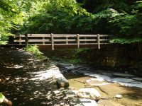
Landmark: Located Between Bridge 7 And 8
Nearest Intersection: Hwy 38 and Hwy 38a and N Main St
Directions: From I-81 South in Cortland, take exit 12 to the right onto US-11/Rt-41 towards Rt-281/Homer/Cortland and drive .4 miles. Keep left onto S West St ramp and drive .5 miles. Take the Rt-281 N ramp to the right towards Tr-90/Homer and drive .4 miles. Turn left onto Cayuga St and drive 10.4 miles. Turn right onto Toll Gate Rd and drive 3.8 miles. Turn right onto Hwy 38 and drive .3 miles. There will be signs along the way to help direct you to the park.
Comments, Notes: ————-