
Waterfall Name: Bucks Brook, falls on #1
Aka: ————-
Location: Otselic Twn
First Visit: 04-17-2016
State: New York State
Region: Central Region
County: Chenango County
Park Area: Bucks Brook State Forest
NYS Tourism Region: Central Leatherstocking
NYDEC Region: Central New York
Waterfall Challenge:————-
Waterfall Location: N42.69208 W75.77611
Parking: N42.68418 W75.76543
Trailhead: N42.68418 W75.76543
Trail Name, Reference to: M22 Finger Lakes Trail/Roadside
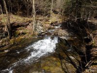
Stream, River: Bucks Brook
Height, Type: series of small waterfalls ledges cascades
Elevation: 1571 ft to 1343 ft
Level of Difficulty, Hiking Distance: Roadside view
Whitewater Rte, Canoe Rte Map: ————-
Maps: M22 Finger Lakes Trail white blazed
My Resource: Finger Lakes Trail Guide Maps
Book Resource: ————-
Brochures, Travel Guides, Visitor Guides: ————-
Trail_URL: ————-
Additional Information: ————-
Photos, Information Contributed to other Websites: Dig the Falls
Landmark: Finger Lakes Trail white blazed
Nearest Intersection: Bucks Brook Rd and Valley View Rd
Directions: From Hwy 80 and Hwy 26, in Ostelic Twn, Get on Hwy 26 and drive south for 3.4 miles. Turn right onto Valley View Rd and in only a few hundred feet you will come to the intersection of Bucks Brook Rd and Valley View Rd.
Comments, Notes: Starting at the intersection of Bucks Brook Road and Valley View Road, work your way up Bucks Brook Road, you will see the series of small ledges, cascades, small falls. I had recorded the gps locations for the biggest ones.
————-
————-
————-

Pingback: Bucks Brook – 2 Waterfalls and a Dam | Bobbieswaterfalls