
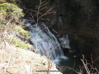
Waterfall Name: Rexford Falls
Aka: ————-
Location: Sherburne Twn
First Visit: 04-03-2008
State: New York State
Region: Central Region
County: Chenango County
Park Area: Rexford Town Park
NYS Tourism Region: Central Leatherstocking
NYDEC Region: Central New York
Waterfall Challenge:————-
Waterfall Location: N42.67898 W75.47203
Parking: N42.67851 W75.47076
Trailhead: N42.67851 W75.47076
Trail Name, Reference to: ————-
Stream, River: Mad Brook
Height, Type: 30-40ft Drop
Elevation: 1225 ft
Level of Difficulty, Hiking Distance: .1 Mile roundtrip
Whitewater Rte, Canoe Rte Map: ————-
Maps: Delorme Atlas & Gazetteer New York State 9th Edition 2011
My Resource: Eastern New York all outdoors Atlas and Field Guide Publication 2008,E2,pg30
Book Resource: 200 Waterfalls in Central and Western New York: A Finder’s Guide Paperback – June 5, 2018, by Rich and Sue Freeman,Waterfalls in Chemung, Tioga, Broome, Cortland & Chenango Counties,pg307
Brochures, Travel Guides, Visitor Guides: ————-
Trail_URL: ————-
Additional Information: Mohawk Region Waterfall Guide: From the Capital District to Cooperstown & Syracuse: The Mohawak and Schoharie Valleys, Helderbergs, and Leatherstocking Country, Paperback – June 12, 2007, by Russell Dunn,Waterfalls Along Route 20,pg156
Photos, Information Contributed to other Websites: Dig the Falls
Landmark: There Is A Historical Marker Showing 2006 Rexford Falls Footbridge Restoration
Nearest Intersection: Chapel St (Rte 80) and Rexford Falls Rd
Directions: From the intersection of Hwy 12 and Hwy 80 in Sherburne, Get on E State St and drive east for 1.6 miles. Turn right onto Rexford Falls Rd and drive for .2 miles.
Comments, Notes: There is parking on both sides of the park. Either right on Rexford Falls Road, or fron Route 80 side.There is a trail on both sides of the falls.
————-
————-
————-

you can hike up to the base from the baseball fields
Thank You for the information