
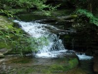
Waterfall Name: Tompkins Falls
Aka: ————-
Location: Andes Twn
First Visit: 08-10-2014
State: New York State
Region: Central Region
County: Delaware County
Park Area: ————-
NYS Tourism Region: Catskill Mountains
NYDEC Region: Capital Region/Northern Catskills
Waterfall Challenge:————-
Waterfall Location: N42.07477 W74.76499
Parking: N42.07507 W74.76337
Trailhead: ————-
Trail Name, Reference to: ————-
Stream, River: Barkaboom Stream
Height, Type: 3ft,6ft,8ft
Elevation: 1525 ft
Level of Difficulty, Hiking Distance: Roadside view
Whitewater Rte, Canoe Rte Map: ————-
Maps: Delorme Atlas & Gazetteer New York State 9th Edition 2011
My Resource: Eastern New York all outdoors Atlas and Field Guide Publication 2008,D3,pg148
Book Resource: Catskill Region Waterfall Guide: Cool Cascades of the Catskills & Shawangunks, Paperback – September 30, 2004, by Russell Dunn, Section I: Waterfalls of the Catskills, Cloves of the Catskills-Near Margaretville,pg99
Brochures, Travel Guides, Visitor Guides: ————-
Trail_URL: ————-
Additional Information: World Waterfall Database
Photos, Information Contributed to other Websites: ————-
Landmark: ————-
Nearest Intersection: Barkaboom Rd and Conklin Brook Rd
Directions: From the intersection of Hwy 28 and Bridge St (Hwy 30) in Margaretville, Get on Hwy 28 and drive southwest for 3.4 miles. Turn left onto Hwy 30 and drive for 8.3 miles. Turn left onto Bws Rd and drive for 1.9 miles. Turn right onto Barkaboom Rd and drive for 1.4 miles.
Comments, Notes: This is located directly on a blind curve. Go past the falls to a small pull off on the right handside of the road. There is a trail that leads down to the falls. Use caution as it was quite slippery, as well as the drop off is dangerous. The best and safest views can be had from the roadside.
————-
————-
————-
