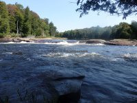
Waterfall Name: Moshier Upper Falls #2 Unnamed Rapids
Aka: ————-
Location: Webb Twn
First Visit: 09-04-2016
State: New York State
Region: Central Region
County: Herkimer County
Park Area: ————-
NYS Tourism Region: Adirondack Mountains
NYDEC Region: Western Adirondacks/Eastern Lake Ontario
Waterfall Challenge:————-
Waterfall Location: N43.88630 W75.11907
Parking: N43.88503 W75.10730
Trailhead: ————-
Trail Name, Reference to: ————-
Stream, River: Beaver River
Height, Type: Class III Rapids
Elevation: 1543 ft
Level of Difficulty, Hiking Distance: .5 mile Roundtrip
Whitewater Rte, Canoe Rte Map: http://www.americanwhitewater.org/content/River/detail/id/2613/
Maps: ————-
My Resource: Beaver River Canoe Rte
Book Resource: ————-
Brochures, Travel Guides, Visitor Guides: ————-
Trail_URL: ————-
Additional Information: ————-
Photos, Information Contributed to other Websites: Dig the Falls, Northern New York Waterfalls
Landmark: Trail entry N43.88385 W75.11946
Nearest Intersection: Stillwater Rd and Number Four Rd and Buck Point Rd
Directions: From County Rte 28 and Big Moose Rd, in Eagle Bay, Get on Big Moose Rd and drive north for 5.8 miles. Turn left onto Big Moose Rd and drive for 11.7 miles. Turn left onto Number Four Rd and drive for 5.7 miles. Turn right onto Moshier Rd and drive for .6 miles.
Comments, Notes: ————-
————-
————-