
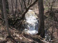
Waterfall Name: Buttermilk Falls, Lincoln Twn
Aka: ————-
Location: Lincoln Twn
First Visit: 04-03-2008
State: New York State
Region: Central Region
County: Madison County
Park Area: ————-
NYS Tourism Region: Central Leatherstocking
NYDEC Region: Central New York
Waterfall Challenge:————-
Waterfall Location: N43.04889 W75.71179
Parking: N43.04881 W75.71109
Trailhead: ————-
Trail Name, Reference to: ————-
Stream, River: Limestone Creek
Height, Type: 30ft,Cascade
Elevation: 692 ft
Level of Difficulty, Hiking Distance: Roadside views
Whitewater Rte, Canoe Rte Map: ————-
Maps: Delorme Atlas & Gazetteer New York State 9th Edition 2011
My Resource: Western New York All-Outdoors Atlas & Field Guide, 2008,B3,pg136
Book Resource: ————-
Brochures, Travel Guides, Visitor Guides: ————-
Trail_URL: ————-
Additional Information: World Waterfall Database
Photos, Information Contributed to other Websites: Dig the Falls
Landmark: ————-
Nearest Intersection: Timmerman Rd and Tuttle Rd
Directions: From I-90 W, in Canastota, Take exit 34 to the right onto Rt-13 towards Canastota/Chittenango and drive for 4.0 miles. When you cross route 5, it changes to Oxbow Rd. Turn left onto Old County Rd W and drive for .2 miles. Bear left onto Timmerman Rd and drive for 1.7 miles.
Comments, Notes: Private Property Best seen in the fall.
————-
————-
————-

Pingback: Updated Waterfall Locations in Lincoln Town, Madison County New York 3-4-2016 - Bobbieswaterfalls
Pingback: Day Trip Madison County New York Area 4/6/2014 - Bobbieswaterfalls