
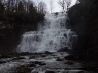
Waterfall Name: Chittenango Falls State Park – Upper Falls #1
Aka: Chittenango Falls, #1 across the road
Location: Cazenovia Twn
First Visit: 07-04-2001
State: New York State
Region: Central Region
County: Madison County
Park Area: Chittenango Falls State Park
NYS Tourism Region: Central Leatherstocking
NYDEC Region: Central New York
Waterfall Challenge:————-
Waterfall Location: N42.97766 W75.84111
Parking: N42.97791 W75.84243
Trailhead: ————-
Trail Name, Reference to: ————-
Stream, River: Chittenango Creek
Height, Type: 2ft overhung waterfall,series of small drops
Elevation: 881 ft
Level of Difficulty, Hiking Distance: 1 Hour Loop
Whitewater Rte, Canoe Rte Map: ————-
Maps: ————-
My Resource: Google Imagery
Book Resource: Mohawk Region Waterfall Guide: From the Capital District to Cooperstown & Syracuse: The Mohawak and Schoharie Valleys, Helderbergs, and Leatherstocking Country, Paperback – June 12, 2007, by Russell Dunn,Waterfalls Along Route 20,pg164
Brochures, Travel Guides, Visitor Guides: ————-
Trail_URL: ————-
Additional Information: 200 Waterfalls in Central and Western New York: A Finder’s Guide Paperback – June 5, 2018, by Rich and Sue Freeman,Waterfalls in Onondaga, Madison and Oneida Counties,pg343
Photos, Information Contributed to other Websites: ————-
Landmark: ————-
Nearest Intersection: Rte 13 (Gorge Rd) and Falls Rd
Directions: From I-90 W, in Canastota, Take exit 34 to the right onto Rt-13 towards Canastota/Chittenango and drive for 2.1 miles. Turn right onto Seneca Tpke and drive for 5.9 miles. Turn left onto Genesee St and drive for .7 miles. Turn left onto Falls Blvd and drive for 5.3 miles. Turn right into the park.
Comments, Notes: ————-
————-
————-
————-
