
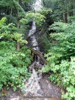
Waterfall Name: Buttermilk Falls, Western Twn
Aka: ————-
Location: Western Twn
First Visit: 07-29-2013
State: New York State
Region: Central Region
County: Oneida County
Park Area: ————-
NYS Tourism Region: Central Leatherstocking
NYDEC Region: Western Adirondacks/Eastern Lake Ontario
Waterfall Challenge:————-
Waterfall Location: N43.34940 W75.37185
Parking: N43.34940 W75.37185
Trailhead: ————-
Trail Name, Reference to: ————-
Stream, River: Mohawk River
Height, Type: ————-
Elevation: 625 ft
Level of Difficulty, Hiking Distance: Roadside views
Whitewater Rte, Canoe Rte Map: ————-
Maps: ————-
My Resource: A local guy pointed us to this waterfall and stated it was called Buttermilk.
Book Resource: ————-
Brochures, Travel Guides, Visitor Guides: ————-
Trail_URL: ————-
Additional Information: ————-
Photos, Information Contributed to other Websites: Dig the Falls
Landmark: ————-
Nearest Intersection: Hillside Rd and Hwy 46
Directions: From I-90 W, in Westmoreland, Take exit 32 to the right towards Rt-233/Westmoreland/Rome and drive for .7 miles. Turn right onto Cider St and drive for .1 miles. Turn right onto Hwy 233 and drive for 5.7 miles. Take the Rt-49 W/Rt-69 W/Rt-365 W ramp to the left and drive for .4 miles. Take the Rt-49 W/Rt-69 W ramp to the right towards Rt-26 N/Rt-46/Downtown Rome and drive for 1.3 miles. Keep right onto Rd and drive for 3.3 miles. Keep right onto Rome Westernville Rd and drive for 9.1 miles. Turn left onto Hillside Rd for 359 ft, the falls will be on your right.
Comments, Notes: Maybe a seasonal runoff. We were driving around this area.
————-
————-
————-
