
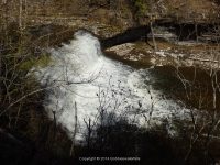
Waterfall Name: Cincinnati Creek, Upper Falls
Aka: ————-
Location: Trenton Twn
First Visit: 03-30-2013
State: New York State
Region: Central Region
County: Oneida County
Park Area: ————-
NYS Tourism Region: Central Leatherstocking
NYDEC Region: Western Adirondacks/Eastern Lake Ontario
Waterfall Challenge:————-
Waterfall Location: N43.28424 W75.17165
Parking: N43.28297 W75.17153
Trailhead: ————-
Trail Name, Reference to: ————-
Stream, River: Cincinnati Creek/Mud Creek
Height, Type: ————-
Elevation: 888 ft
Level of Difficulty, Hiking Distance: Roadside views
Whitewater Rte, Canoe Rte Map: http://www.americanwhitewater.org/content/River/detail/id/3568#main
Maps: ————-
My Resource: World Waterfall Database
Book Resource: ————-
Brochures, Travel Guides, Visitor Guides: ————-
Trail_URL: ————-
Additional Information: ————-
Photos, Information Contributed to other Websites: Dig the Falls, Northern New York Waterfalls
Landmark: There Is A Stone Wall Barrier Along This Section Of The Road
Nearest Intersection: Rte 365 and Parker Rd
Directions: From I-90, in Utica, Take exit 31 to the right towards I-790/Rt-8/Rt-12/Utica and drive for .8 miles. Take the Genesee St North ramp to the right towards Rt-5/Rt-8/Rt-12/Rt-49/I-790 W/Watertown/Rome and drive for .4 miles. Keep left onto Trenton Rd and drive for 1.6 miles. Continue on Cr-91 N towards Rt-12/Glass Factory Rd and drive for .3 miles. Take the Rt-8 N/Rt-12 N ramp to the right and drive for 10.7 miles. Take the Rt-365 ramp to the right towards Barneveld/Prospect/Rome and drive for .2 miles. Turn right onto Hwy 365 and drive for .4 miles. Turn right onto Parker Hollow Rd and drive for .5 miles.
Comments, Notes: You have to park either before the curve or after the curve and walk to the stone bridge. Please take caution as the road is narrow and as stated is on a hazardouse curve.
————-
https://bobbieswaterfalls.com/wp-content/uploads/2018/02/CINCINNATI-CREEK-FALLS-ONEIDA-COUNTY-CENTRAL-NEW-YORK-3-30-2013_00010.jpg
————-
