
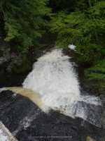
Waterfall Name: Buttermilk Falls (Otsego)
Aka: Ferris Falls First Falls
Location: Decanter Twn
First Visit: 05-25-2013
State: New York State
Region: Central Region
County: Otsego County
Park Area: ————-
NYS Tourism Region: Central Leatherstocking
NYDEC Region: Capital Region/Northern Catskills
Waterfall Challenge:————-
Waterfall Location: N42.65651 W74.69627
Parking: N42.65651 W74.69627
Trailhead: ————-
Trail Name, Reference to: ————-
Stream, River: Oak Creek
Height, Type: Tiered
Elevation: ————-
Level of Difficulty, Hiking Distance: Roadside views
Whitewater Rte, Canoe Rte Map: ————-
Maps: Delorme Atlas & Gazetteer New York State 9th Edition 2011
My Resource: Eastern New York all outdoors Atlas and Field Guide Publication 2008,E3,pg132
Book Resource: ————-
Brochures, Travel Guides, Visitor Guides: ————-
Trail_URL: ————-
Additional Information: World Waterfall Database, Geology Website
Photos, Information Contributed to other Websites: Dig the Falls
Landmark: This Is Located Directly Under The Road
Nearest Intersection: Co Rd 38 and Lum Rd
Directions: From I-90 W, in Canajoharie, Take exit 29 to the right towards Rt-10/Canajoharie/Sharon Springs and drive for .7 miles.Turn right onto E Main St and drive for .2 miles. Turn left onto Church St for 485 ft. Turn right onto Cliff St and drive for .1 miles. Turn left onto Walnut St and drive for 15.9 miles. Turn right onto Gardnersville Rd and drive for 1 miles. Turn right onto Hwy 165 and drive for 1.4 miles. Turn left onto W Richmondville Rd and drive for 5.3 miles. Turn left onto North Rd and drive for 1.2 miles.
Comments, Notes: ————-
————-
————-
————-
