Waterfall Name: Salt Springville Road (falls on)
Aka: Salt Springville Road, Cascade on
Location: Cherry Valley Twn
First Visit: 03-06-2010
State: New York State
Region: Central Region
County: Otsego County
Park Area: ————-
NYS Tourism Region: Central Leatherstocking
NYDEC Region: Capital Region/Northern Catskills
Waterfall Challenge:————-
Waterfall Location: N42.83776 W74.74974
Parking: N42.83776 W74.74974
Trailhead: ————-
Trail Name, Reference to: ————-
Stream, River: Canajoharie Creek, Tributary to
Height, Type: 60ft,Cascade
Elevation: 1446 ft
Level of Difficulty, Hiking Distance: Roadside views
Whitewater Rte, Canoe Rte Map: ————-
Maps: ————-
My Resource: Mohawk Region Waterfall Guide: From the Capital District to Cooperstown & Syracuse: The Mohawak and Schoharie Valleys, Helderbergs, and Leatherstocking Country, Paperback – June 12, 2007, by Russell Dunn,Waterfalls Along Route 20,pg146
Book Resource: Mohawk Region Waterfall Guide: From the Capital District to Cooperstown & Syracuse: The Mohawak and Schoharie Valleys, Helderbergs, and Leatherstocking Country, Paperback – June 12, 2007, by Russell Dunn,Waterfalls Along Route 20,pg146
Brochures, Travel Guides, Visitor Guides: ————-
Trail_URL: ————-
Additional Information: World Waterfall Database
Photos, Information Contributed to other Websites: Dig the Falls
Landmark: ————-
Nearest Intersection: Salt Springville Rd and US 20
Directions: From I-90 W, in Canajoharie, Take exit 29 to the right towards Rt-10/Canajoharie/Sharon Springs and drive for .7 miles. Turn right onto E Main St and drive for 3.6 miles. Turn left onto Main St and drive for 2.7 miles. Keep left onto Cherry Valley Rd and drive for 3 miles. Turn right onto Indian Trail Rd and drive for 3.3 miles. Turn left onto Salt Springville Rd and drive for 1.5 miles.
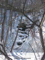
Comments, Notes: Will have to go back, not sure if we found it or not. There was no water running, but appeared we had the location.
————-
————-
————-