
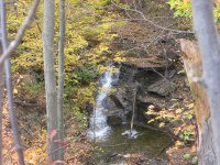
Waterfall Name: Sixteen Falls Creek (falls on)
Aka: ————-
Location: Ovid Twn
First Visit: 10-19-2010
State: New York State
Region: Central Region
County: Seneca County
Park Area: ————-
NYS Tourism Region: Finger Lakes-Wine Country
NYDEC Region: Western Finger Lakes
Waterfall Challenge:————-
Waterfall Location: N42.65180 W76.83499
Parking: N42.65180 W76.83499
Trailhead: ————-
Trail Name, Reference to: Trail N42.64892 W76.85482 Trail N42.63639 W76.85203 Trail N42.64558 W76.84561
Stream, River: Sixteen Falls Creek
Height, Type: fair size waterfall and several small cascades along the roadside
Elevation: ————-
Level of Difficulty, Hiking Distance: ————-
Whitewater Rte, Canoe Rte Map: ————-
Maps: ————-
My Resource: Driveby
Book Resource: ————-
Brochures, Travel Guides, Visitor Guides: ————-
Trail_URL: ————-
Additional Information: ————-
Photos, Information Contributed to other Websites: Dig the Falls
Landmark: ————-
Nearest Intersection: Highway 96a (Highway 414) and Combs Rd
Directions: From I-90 W, near Magee, Take exit 41 to the right onto Rt-414 towards Waterloo/Clyde and drive for .8 miles. Take the Rt-414 S ramp to the right towards US-20/Rt-5/Waterloo/Seneca Falls and drive for 4.5 miles. Turn right onto E River Rd and drive for 1.4 miles. Turn left onto Fayette St and drive for 17.7 miles. Turn right onto Combs Rd and drive for .5 miles. Turn right onto McCarriger Rd, for a few hundred feet.
Comments, Notes: We found other small falls along the road, but could not find the access to the main falls yet.
————-
————-
————-

Pingback: Updated Waterfall Locations in Seneca County New York 2-26-2016 | Bobbieswaterfalls
Pingback: THE FOLLOWING PAGES ARE NOW PUBLISHED 3/21/2015 | Bobbieswaterfalls