
Waterfall Name: Buttermilk Falls ,Owego
Aka: ————-
Location: Owego Twn
First Visit: 08-09-2014
State: New York State
Region: Central Region
County: Tioga County
Park Area: ————-
NYS Tourism Region: Finger Lakes-Wine Country
NYDEC Region: Central New York
Waterfall Challenge:————-
Waterfall Location: N42.131749 W76.287702
Parking: N42.13204 W76.28651
Trailhead: ————-
Trail Name, Reference to: ————-
Stream, River: Catatonk Creek, Unnamed Tributary
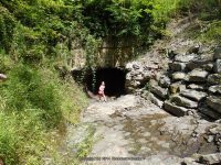
Height, Type: 50ft,Staircase Cascade
Elevation: 950 ft
Level of Difficulty, Hiking Distance: Short
Whitewater Rte, Canoe Rte Map: ————-
Maps: Delorme Atlas & Gazetteer New York State 9th Edition 2011
My Resource: Western New York All-Outdoors Atlas & Field Guide, 2008,C2,pg86
Book Resource: 200 Waterfalls in Central and Western New York: A Finder’s Guide Paperback – June 5, 2018, by Rich and Sue Freeman,Waterfalls in Chemung, Tioga, Broome, Cortland & Chenango Counties,pg302
Brochures, Travel Guides, Visitor Guides: ————-
Trail_URL: ————-
Additional Information: ————-
Photos, Information Contributed to other Websites: Dig the Falls
Landmark: ————-
Nearest Intersection: Spaulding Hill Rd and Glen Mary Dr
Directions: From the intersection of, Hwy 38 and Hwy 17c and Academy St in Owego, Get on McMaster St and drive north 456 ft. Turn right onto Temple St and drive for .2 miles. Turn left onto North Ave and drive for .3 miles. Turn left onto West Ave and drive for .5 miles. Turn right onto Cove St and drive for .1 miles. Turn left onto Talcott St for .1 miles. Turn right onto Glen Mary Drive and drive for 1.5 miles. Turn left onto Spaulding Hill Rd and drive for .3 miles.
Comments, Notes: Even though there was no water flow, we had a great time exploring.
————-
————-
————-
