

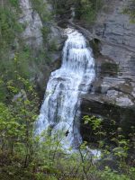
Waterfall Name: Robert H. Treman, Lucifer Falls
Aka: Lucifer Falls (Enfield Glen)
Location: Newfield
First Visit: 07-15-2006
State: New York State
Region: Central Region
County: Tompkins County
Park Area: Robert H. Treman State Park
NYS Tourism Region: Finger Lakes-Wine Country
NYDEC Region: Central New York
Waterfall Challenge:Finger Lakes Region Waterfall Challenge Paperback – October 30, 2019, by John Haywood, Julie Hughes Romano, Bella Romano, Edward Smathers,Tompkins,pg98
Waterfall Location: N42.40051 W76.58422
Parking: N42.402385 W76.589320
Trailhead: Lower Parking Area #01 N42.39798 W76.55653, Lower Parking Area #02 N42.39692 W76.55631, Lower Parking Area #03 N42.39613 W76.55761, Lower Parking Area #04 N42.39602 W76.55565, Upper Parking N42.40221 W76.59022
Trail Name, Reference to: https://parks.ny.gov/parks/attachments/RobertHTremanTrailMap.pdf
Stream, River: Enfield Creek, once called Five Mile Creek
Height, Type: 115ft Freefall Cascade
Elevation: 828 ft
Level of Difficulty, Hiking Distance: Gorge Trail: 2.25mi./Rim Trail: 2.25mi./Red Pine Trail: 0.5mi./CCC Memorial Trail: 0.33mi.
Whitewater Rte, Canoe Rte Map: ————-
Maps: Western New York All-Outdoors Atlas & Field Guide, 2008,C5,pg103
My Resource: 200 Waterfalls in Central and Western New York: A Finder’s Guide Paperback – June 5, 2018, by Rich and Sue Freeman,Waterfalls in Schuyler and Tompkins Counties,pg262
Book Resource: New York Waterfalls “A Guide For Hikers & Photographers” by Scott E. Brown 2010
Brochures, Travel Guides, Visitor Guides: ————-
Trail_URL: http://nyfalls.com/waterfalls/robert-treman-state-park/
Additional Information: http://falzguy.com/robert-treman-park.html
Photos, Information Contributed to other Websites: Dig the Falls
Landmark: Enfield Falls
Nearest Intersection: Hwy 327 (Enfield Falls Rd) and Upper Robert Treman Park Rd
Directions: From Ithaca, take NYS route 13 south about 5 miles to the junction with NYS route 327 on the right. At this point you will see a sign for the Park. Turn right onto 327, and then immediately turn left into the park. To reach the upper parking area, continue about 2 and a half miles on 327. The upper entrance will be on the left. Follow the park road to the upper parking area.
Comments, Notes: There a a few more waterfalls located in these approximate locations. N42.39987 W76.58047 and N42.40053 W76.58475
————-
————-