
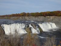
Waterfall Name: Cohoes Falls
Aka: Buttermilk Falls
Location: Cohoes
First Visit: 10-21-2013
State: New York State
Region: Eastern Region
County: Albany County
Park Area: Cohoes Falls Overlook Park/Falls View Park
NYS Tourism Region: Capital-Saratoga
NYDEC Region: Capital Region/Northern Catskills
Waterfall Challenge: Hudson Valley Waterfall Challenge Paperback – March 9, 2020, by John Haywood, Albany, pg4
Waterfall Location: N42.7874 W73.70906
Parking: N42.7854091 W73.7092041
Trailhead: N42.785647 W73.710822
Trail Name, Reference to: Falls View Park N42.7854091 W73.7092041 Falls View Parking #2 N42.78467 W73.70715
Stream, River: Mohawk River
Height, Type: 90ft,Curtain
Elevation: 125 ft
Level of Difficulty, Hiking Distance: Roadside view or a short walk/viewable from 2 parks near falls
Whitewater Rte, Canoe Rte Map: http://www.americanwhitewater.org/content/River/detail/id/1347#main, Mohawk Cohoes Falls to Hudson River
Maps: Eastern New York all outdoors Atlas & Field Guide Publication 2008 136 C1
My Resource: Eastern New York all outdoors Atlas & Field Guide Publication 2008 136 C1
Book Resource: Hudson Valley Waterfall Guide: From Saratoga and the Cpaital Region to the Highlands and Palisades, Paperback – First Edition 2006, by Russell Dunn,Capital Region-Westside of the Hudson River: From Schuylerville to Catskill,pg135
Brochures, Travel Guides, Visitor Guides: ————-
Trail_URL: http://www.cohoes.com/cit-e-access/webpage.cfm?TID=34&TPID=9360, Overlook Park & Falls View Park
Additional Information: Mohawk Region Waterfall Guide: From the Capital District to Cooperstown & Syracuse: The Mohawak and Schoharie Valleys, Helderbergs, and Leatherstocking Country, Paperback – June 12, 2007, by Russell Dunn,Waterfalls of the Mohawk Valley,pg35
Photos, Information Contributed to other Websites: Northern New York Waterfalls
Landmark: Craner Park Or Calvery Grace Church
Nearest Intersection: Church St and N Mohawk St and Devlin St
Directions: From I-87 N Latham, Take exit 7 to the right onto Rt-7 E towards Troy/Cohoes and drive for .4 miles. Take the US-9 ramp to the right towards Rt-9r/Latham/Cohoes and drive for .2 miles. Keep right onto Loudon Rd ramp and drive for 209 ft. Turn right onto Loudon Rd and drive for 1.9 miles. Turn right onto Boght Rd and drive for .7 miles. Keep left onto Boght Rd and drive for 1 miles. Turn right onto N Mohawk St. and drive for .3 miles. Turn left onto School St. and drive for 499 ft.
Comments, Notes: There are two areas for viewing of these falls.
Map_URL:
