
Waterfall Name: Canajoharie Lower Gorge Falls
Aka: ————-
Location: Canajoharie Twn
First Visit: 03-17-2011
State: New York State
Region: Eastern Region
County: Montgomery County
Park Area: ————-
NYS Tourism Region: Central Leatherstocking
NYDEC Region: Capital Region/Northern Catskills
Waterfall Challenge: ————-
Waterfall Location: N42.89963 W74.57243
Parking: N42.89916 W74.57143
Trailhead: ————-
Trail Name, Reference to: ————-
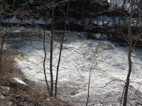
Stream, River: Canajoharie Creek
Height, Type: 24ft,8ft,Small Falls and Cacades and Series of Step Ledges
Elevation: 350 ft
Level of Difficulty, Hiking Distance: .2 Mile Roundtrip
Whitewater Rte, Canoe Rte Map: ————-
Maps: ————-
My Resource: Mohawk Region Waterfall Guide: From the Capital District to Cooperstown & Syracuse: The Mohawak and Schoharie Valleys, Helderbergs, and Leatherstocking Country, Paperback – June 12, 2007, by Russell Dunn,Waterfalls of the Mohawk Valley,pg95
Book Resource: Mohawk Region Waterfall Guide: From the Capital District to Cooperstown & Syracuse: The Mohawak and Schoharie Valleys, Helderbergs, and Leatherstocking Country, Paperback – June 12, 2007, by Russell Dunn,Waterfalls of the Mohawk Valley,pg95
Brochures, Travel Guides, Visitor Guides: ————-
Trail_URL: ————-
Additional Information: Waterfalls of New York State Paperback – August 9, 2012, by Scott Ensminger, David Schryver, Edward Smathers,Capital Region,pg28
Photos, Information Contributed to other Websites: Dig the Falls
Landmark: Canajoharie Pothole “Devil’s Ear”
Nearest Intersection: Moyer St. and Barclay St. and Rd and Floral Ave
Directions: From I-90 W in Canajoharie, Take exit 29 to the right towards Rt-10/Canajoharie/Sharon Springs and drive for .7 miles. Turn right onto E Main St and drive for .2 miles. Turn left onto Mitchell St for 382 ft. Turn left onto Montgomery St for 89 ft. Turn right onto Moyer St and drive for .3 miles. Turn right onto Floral Ave and drive for .1 miles.
Comments, Notes: ————-
Map_URL: