
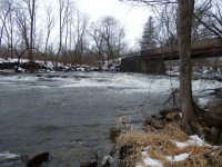
Waterfall Name: Cayadutta Creek, Falls on
Aka: Berryville Falls
Location: Mohawk Twn
First Visit: 01-13-2013
State: New York State
Region: Eastern Region
County: Montgomery County
Park Area: ————-
NYS Tourism Region: Central Leatherstocking
NYDEC Region: Capital Region/Northern Catskills
Waterfall Challenge: ————-
Waterfall Location: N42.96314 W74.41557
Parking: N42.96193 W74.41411
Trailhead: ————-
Trail Name, Reference to: ————-
Stream, River: Cayadutta Creek
Height, Type: 3ft Upper,6ft Lower,Curtain Cascade
Elevation: 371 ft
Level of Difficulty, Hiking Distance: Roadside views
Whitewater Rte, Canoe Rte Map: ————-
Maps: ————-
My Resource: Mohawk Region Waterfall Guide: From the Capital District to Cooperstown & Syracuse: The Mohawak and Schoharie Valleys, Helderbergs, and Leatherstocking Country, Paperback – June 12, 2007, by Russell Dunn,Waterfalls of the Mohawk Valley,pg85
Book Resource: Mohawk Region Waterfall Guide: From the Capital District to Cooperstown & Syracuse: The Mohawak and Schoharie Valleys, Helderbergs, and Leatherstocking Country, Paperback – June 12, 2007, by Russell Dunn,Waterfalls of the Mohawk Valley,pg85
Brochures, Travel Guides, Visitor Guides: ————-
Trail_URL: ————-
Additional Information: ————-
Photos, Information Contributed to other Websites: Dig the Falls, Northern New York Waterfalls
Landmark: Bridge
Nearest Intersection: Rte 334 Cayadutta St. and Commons Rd
Directions: From I-90 Fonda, Take exit 28 to the right towards Rt-30a/Fultonville/Fonda and drive for .4 miles. Take ramp towards Rt-30a/Rt-5s/Rt-5/Johnstown/Gloversville for 184 ft. Turn left onto Riverside Dr and drive for .6 miles. Turn right onto S Bridge St and drive for .4 miles. Turn left onto E Main St and drive for .6 miles. Turn right onto Cayadutta St and drive for 2 miles. Turn right onto Commons Rd for 228 ft.
Comments, Notes: ————-
Map_URL:
