
Waterfall Name: Cider Mill Falls, South Amsterdam
Aka: ————-
Location: Florida Twn
First Visit: 01-13-2013
State: New York State
Region: Eastern Region
County: Montgomery County
Park Area: Mudge Hollow
NYS Tourism Region: Central Leatherstocking
NYDEC Region: Capital Region/Northern Catskills
Waterfall Challenge: ————-
Waterfall Location: N42.93422 W74.21526
Parking: N42.93419 W74.21419
Trailhead: ————-
Trail Name, Reference to: ————-
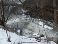
Stream, River: South Chuctanunda
Height, Type: 6ft,Ledges Cascade
Elevation: 325 ft
Level of Difficulty, Hiking Distance: Roadside views
Whitewater Rte, Canoe Rte Map: ————-
Maps: ————-
My Resource: Mohawk Region Waterfall Guide: From the Capital District to Cooperstown & Syracuse: The Mohawak and Schoharie Valleys, Helderbergs, and Leatherstocking Country, Paperback – June 12, 2007, by Russell Dunn,Waterfalls of the Mohawk Valley,pg83
Book Resource: Mohawk Region Waterfall Guide: From the Capital District to Cooperstown & Syracuse: The Mohawak and Schoharie Valleys, Helderbergs, and Leatherstocking Country, Paperback – June 12, 2007, by Russell Dunn,Waterfalls of the Mohawk Valley,pg83
Brochures, Travel Guides, Visitor Guides: ————-
Trail_URL: ————-
Additional Information: ————-
Photos, Information Contributed to other Websites: Dig the Falls, Northern New York Waterfalls
Landmark: Under The Route 5s Bridge
Nearest Intersection: Florida Ave and Daniel St.
Directions: From I-90 Amsterdam, Take exit 27 to the right onto Rt-30 towards Amsterdam and drive for .4 miles. Take the Rt-30 N ramp to the right towards Rt-5s/Rt-5/Rt-67 for 304 ft. Take the Rt-5s ramp to the right towards Auriesville/Schenectady for 478 ft. Turn left onto Hwy 5s and drive for .9 miles. Turn left onto Daniel St for 115 ft. Turn right onto Daniel St for 270 ft. Turn right onto Florida Ave for 277 ft.
Comments, Notes: I have also included the seasonal 30 ft Cascades on each side of the bridge, referred to in the book.
Map_URL:
