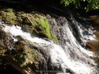
Waterfall Name: Burden Falls #05, Wynants Kill
Aka: Wynants Kill Burden Falls Area Northeast Between Burden Pond And Smart Pond
Location: South Troy
First Visit: 05-14-2015
State: New York State
Region: Eastern Region
County: Rensselaer County
Park Area: Burden Falls Environmental Park
NYS Tourism Region: Capital-Saratoga
NYDEC Region: Capital Region/Northern Catskills
Waterfall Challenge: Hudson Valley Waterfall Challenge Paperback – March 9, 2020, by John Haywood,Rensselear,pg92
Waterfall Location: N42.70723 W73.68038
Parking: N42.70718 W73.67816
Trailhead: ————-
Trail Name, Reference to: ————-
Stream, River: Wynants Kill
Height, Type: ————-
Elevation: 215ft
Level of Difficulty, Hiking Distance: Approx 5 mile rt from parking on Cambell Ave/Varying Hike, Approx .4 mile rt from Dunkin Donuts parking on Cambell Ave
Whitewater Rte, Canoe Rte Map: ————-
Maps: ————-
My Resource: Hudson Valley Waterfall Guide: From Saratoga and the Cpaital Region to the Highlands and Palisades, Paperback – First Edition 2006, by Russell Dunn,Capital Region-Eastside of the Hudson River: From Dionondahowa Falls to the City of Hudson,pg87
Book Resource: Hudson Valley Waterfall Guide: From Saratoga and the Cpaital Region to the Highlands and Palisades, Paperback – First Edition 2006, by Russell Dunn,Capital Region-Eastside of the Hudson River: From Dionondahowa Falls to the City of Hudson,pg87
Brochures, Travel Guides, Visitor Guides: ————-
Trail_URL: ————-
Additional Information: Natural Areas of Rensselaer County, NY
Photos, Information Contributed to other Websites: Dig the Falls
Landmark: above burden pond
Nearest Intersection: Campbell ave and Donegal Ave
Directions: The directions provided here will get you to each of the locations for the waterfalls in this area, considered for the Burden Environmental Park Waterfalls. From I-787 N near Menands, Take exit 7E to the right onto Rt-378 E towards South Troy and drive for 1.1 miles. Turn left onto Kelly St for 237 ft. Turn left onto Cross St for 373 ft. Turn right onto Burden Ave for 337 ft. Keep right onto Water St for 74 ft. Wynants Kill falls on (Near Water St) Parking Perform a U-Turn back onto Water St for 63 ft. Turn right onto Mill St and drive for .2 miles. Wynants Kill Dam And Falls Below Burden Falls Parking for 33 ft. Get on Mill St and drive east and drive for .3 miles. Turn left onto Campbell Ave for 230 ft. Turn right onto Willis St for 35 ft. Burden Falls (on Wynants Kill) Parking Get on Willis St and drive north for 32 ft. Turn right onto Campbell Ave and drive for .6 miles. Wynants Kill Burden Parking
Comments, Notes: From the parking area by the buildings, go out behind the building and you will see the trail that leads directly to the first falls. We confirmed 5 of the 6 waterfalls that are located starting from smarts pond down to burden pond. We were unsure of the status of the property to the last waterfall. The path is fairly easy and easy to follow. When you reach falls number 5 it does get tricky and is a short scramble to get down to it. In the book by russell dunn ” hudson valley waterfall guide, he mentions the main falls is where the pipeline is. Another resource is stating or naming a upper and lower falls here. I have not yet confirmed which is which, so I have numbered them instead. (Falls #1 N42.70797 W73.67852) (Falls #2 N42.70787 W73.67922) (Falls #3 N42.70769 W73.67971) (Falls #4 N42.70743 W73.68005) (Falls #5 N42.70723 W73.68038)(Falls #6 N42.70705 W73.68063 did not see)