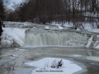
Waterfall Name: Buttermilk Falls, Schaghticoke
Aka: ————-
Location: Schaghticoke Twn
First Visit: 02-22-2014
State: New York State
Region: Eastern Region
County: Rensselaer County
Park Area: ————-
NYS Tourism Region: Capital-Saratoga
NYDEC Region: Capital Region/Northern Catskills
Waterfall Challenge: Hudson Valley Waterfall Challenge Paperback – March 9, 2020, by John Haywood,Rennselear,pg86
Waterfall Location: N42.887919 W73.620085
Parking: N42.88781 W73.62061
Trailhead: ————-
Trail Name, Reference to: ————-
Stream, River: Tomhannock Creek
Height, Type: Over 10ft Cascade
Elevation: 215 ft
Level of Difficulty, Hiking Distance: Roadside Views
Whitewater Rte, Canoe Rte Map: ————-
Maps: ————-
My Resource: Hudson Valley Waterfall Guide: From Saratoga and the Cpaital Region to the Highlands and Palisades, Paperback – First Edition 2006, by Russell Dunn,Capital Region-Eastside of the Hudson River: From Dionondahowa Falls to the City of Hudson,pg67
Book Resource: Hudson Valley Waterfall Guide: From Saratoga and the Cpaital Region to the Highlands and Palisades, Paperback – First Edition 2006, by Russell Dunn,Capital Region-Eastside of the Hudson River: From Dionondahowa Falls to the City of Hudson,pg67
Brochures, Travel Guides, Visitor Guides: ————-
Trail_URL: ————-
Additional Information: Waterfalls of New York State Paperback – August 9, 2012, by Scott Ensminger, David Schryver, Edward Smathers,Capital Region,pg24
Photos, Information Contributed to other Websites: ————-
Landmark: ————-
Nearest Intersection: Rte 67 and Buttermilk Falls Rd
Directions: From I-87 N near Clifton Park, Take exit 9 to the right onto Rt-146 towards Clifton Park/Halfmoon and drive for .2 miles. Take the Rt-146 E ramp to the right towards US-9/Halfmoon/Mechanicville/Stillwater and drive for 2.5 miles. Turn left onto Hwy 146 and drive for 3.3 miles. Turn right onto Ellsworth Ave and drive for .3 miles. Turn left onto Main St S and drive for .5 miles. Turn right onto Hwy 67 and drive for 3.2 miles. Turn right onto Buttermilk Falls Rd and drive for 1.3 miles.
Comments, Notes: The view for the second waterfall downstream is not the greatest, can hardly see it, and is on private property. Hidden falls upstream is on private property and there is no access to