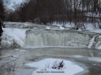
Waterfall Name: Buttermilk Middle Falls, Schaghticoke
Aka: ————-
Location: Schaghticoke Twn
First Visit: 02-22-2014
State: New York State
Region: Eastern Region
County: Rensselaer County
Park Area: ————-
NYS Tourism Region: Capital-Saratoga
NYDEC Region: Capital Region/Northern Catskills
Waterfall Challenge: ————-
Waterfall Location: N42.888022 W73.622296
Parking: N42.88781 W73.62061
Trailhead: ————-
Trail Name, Reference to: ————-
Stream, River: Tomhannock Creek
Height, Type: ————-
Elevation: ————-
Level of Difficulty, Hiking Distance: Private/Roadside Views
Whitewater Rte, Canoe Rte Map: ————-
Maps: ————-
My Resource: World Waterfall Database
Book Resource: Google imagery
Brochures, Travel Guides, Visitor Guides: ————-
Trail_URL: ————-
Additional Information: ————-
Photos, Information Contributed to other Websites: ————-
Landmark: ————-
Nearest Intersection: Rte 67 and Buttermilk Falls Rd
Directions: From I-87 N near Clifton Park, Take exit 9 to the right onto Rt-146 towards Clifton Park/Halfmoon and drive for .2 miles. Take the Rt-146 E ramp to the right towards US-9/Halfmoon/Mechanicville/Stillwater and drive for 2.5 miles. Turn left onto Hwy 146 and drive for 3.3 miles. Turn right onto Ellsworth Ave and drive for .3 miles. Turn left onto Main St S and drive for .5 miles. Turn right onto Hwy 67 and drive for 3.2 miles. Turn right onto Buttermilk Falls Rd and drive for 1.3 miles.
Comments, Notes: The view for the second waterfall downstream is not the greatest, can hardly see it, and is on private property. Hidden falls upstream is on private property and there is no access to