
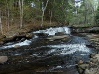
Waterfall Name: Beecher Creek Falls #02
Aka: ————-
Location: Edinburg Twn
First Visit: 05-10-2015
State: New York State
Region: Eastern Region
County: Saratoga County
Park Area: ————-
NYS Tourism Region: Capital-Saratoga
NYDEC Region: Eastern Adirondacks/Lake Champlain
Waterfall Challenge: ————-
Waterfall Location: N43.22086 W74.10680
Parking: N43.22193 W74.10517
Trailhead: ————-
Trail Name, Reference to: ————-
Stream, River: Beecher Creek
Height, Type: ————-
Elevation: 900 ft
Level of Difficulty, Hiking Distance: Roadside view
Whitewater Rte, Canoe Rte Map: ————-
Maps: ————-
My Resource: Driveby
Book Resource: ————-
Brochures, Travel Guides, Visitor Guides: ————-
Trail_URL: ————-
Additional Information: ————-
Photos, Information Contributed to other Websites: Dig the Falls
Landmark: Up The Road From Beecher Creek Falls
Nearest Intersection: North Shore Rd (Cr-4) and Military Rd and Olmstead Rd (Pucker St)
Directions: From I-90 Amsterdam, Take exit 27 to the right onto Rt-30 towards Amsterdam and drive for .4 miles. Take the Rt-30 N ramp to the right towards Rt-5s/Rt-5/Rt-67 and drive for 8.9 miles. Enter Roundabout and drive for 221 ft. Take the 2nd right onto Hwy 30 and drive for 1.6 miles. Turn right onto North St. and drive for 14.3 miles. Turn right onto N Shore Rd and drive for .3 miles. Turn left onto Military Rd and drive for 31 ft. Turn left onto Olmstead Rd and drive for 416 ft.
Comments, Notes: For this location go onto Pucker Street. It is a dead end road. Go to the end, which you can see right from the four corner intersection.
Pingback: Hamilton, Saratoga County Waterfall Trip 5-10-2015 - Bobbieswaterfalls
Pingback: Waterfalls of New York State 100+ Challenge, Dig the Falls part 1, The Capital Region | Bobbieswaterfalls