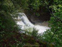
Waterfall Name: Krum’s Falls, Two Waterfalls
Aka: Butts Falls
Location: Fulton Twn
First Visit: 05-25-2013
State: New York State
Region: Eastern Region
County: Schoharie County
Park Area: ————-
NYS Tourism Region: Central Leatherstocking
NYDEC Region: Capital Region/Northern Catskills
Waterfall Challenge: ————-
Waterfall Location: N42.52001 W74.39130
Parking: N42.52023 W74.39102
Trailhead: ————-
Trail Name, Reference to: ————-
Stream, River: Keyserkill
Height, Type: Each Waterfalls is approx. 15ft to 20ft,Cascades
Elevation: 975 ft
Level of Difficulty, Hiking Distance: Roadside the tops are seen from the bridge
Whitewater Rte, Canoe Rte Map: ————-
Maps: ————-
My Resource: Mohawk Region Waterfall Guide: From the Capital District to Cooperstown & Syracuse: The Mohawak and Schoharie Valleys, Helderbergs, and Leatherstocking Country, Paperback – June 12, 2007, by Russell Dunn,Waterfalls of the Schoharie Valley,pg240
Book Resource: ————-
Brochures, Travel Guides, Visitor Guides: ————-
Trail_URL: ————-
Additional Information: ————-
Photos, Information Contributed to other Websites: Dig the Falls
Landmark: Historic Marker Indian Trail
Nearest Intersection: Keyserkill Rd (Rte 17) and Guinea Rd (Rte 53)
Directions: From I-88 W Richmondville, Take exit 20 to the right onto Rt-7 S/Rt-10 S towards Richmondville and drive for 5.1 miles. Turn left onto Summit Lake Rd and drive for .6 miles. Turn left onto Sawyer Hollow Rd and drive for 6.3 miles. Turn right onto W Fulton Rd and drive for 3.9 miles. Turn right onto Hwy 30 and drive for 1.2 miles. Turn left onto Walhalla Rd and drive for .2 miles. Turn left onto Clauverwie Rd and drive for 1.1 miles. Turn right onto Keyserkill Rd and drive for .4 miles. Turn right onto Guinea Rd and drive for .2 miles.
Comments, Notes: ————-