
Waterfall Name: Ausable Chasm – Rainbow Falls
Aka: Adgate Falls, Birmingham Falls, Anderson Falls
Location: Chesterfield Twn
First Visit: 08-17-2008
State: New York State
Region: Northern Region
County: Clinton County
Park Area: Ausable Chasm
NYS Tourism Region: Adirondack Mountains
NYDEC Region: Eastern Adirondacks/Lake Champlain
Waterfall Challenge: Adirondack Fifty Falls Challenge: A Guide to the Fifty Falls, by John Haywood, Russell Dunn, Clinton Essex, pg24
Waterfall Location: N44.52370 W73.46072
Parking: N44.52530 W73.46253
Trailhead: ————-
Trail Name, Reference to: ————-
Stream, River: Ausable River
Height, Type: 70ft,Cascade Ribbon
Elevation: 275 ft
Level of Difficulty, Hiking Distance: Short can be viewed from the bridge
Whitewater Rte, Canoe Rte Map: http://www.americanwhitewater.org/content/River/detail/id/1236/
Maps: Eastern New York all outdoors Atlas and Field Guide Publication 2008,C3,pg96
My Resource: Adirondack Waterfall Guide: New York’s Cool Cascades Paperback – September 1, 2003, by Russell Dunn,, C. Russell Dunn,III. Falls Along The Adirondack Northway, Adirondack Norway,pg167
Book Resource: Keene Valley Region Waterfall Guide: The Search for Cool Cascades in the Heart of the Adirondacks Paperback – November 10, 2017, by C. Russell Dunn,Section VII: From Keene to Keeseville,pg158
Brochures, Travel Guides, Visitor Guides: Adirondack Great Walks & Day Hikes A Guide to paths less taken in the Northeast’s last great wilderness.
Trail_URL: ————-
Additional Information: Ausable Chasm Grand Canyon of the Adirondacks
Photos, Information Contributed to other Websites: Northern New York Waterfalls
Landmark: Hydroelectric power house on the right
Nearest Intersection: Rte 9 and Old State Rd
Directions: From I-87 N in Keeseville, Take exit 34 to the right onto Rt-9n towards Ausable Forks/Keeseville for .3 miles. Turn right onto Hwy 9n and drive for 1.3 miles. Turn left onto US 9 and drive for 1.5 miles.
Comments, Notes: I had previously called the small ribbon like falls you see to the right from the bridge Rainbow Falls and I called the falls on the left Main Falls. It is called Rainbow Falls. The Ribbon like falls on the right is an outlet from the hydroelectric facility rack house.
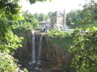
MAIN FALLS at AUSABLE CHASM


————-
————-
Pingback: Waterfalls of New York State 100+ Challenge, Dig the Falls, part 5, The North Country Region - Bobbieswaterfalls