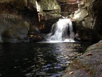
Waterfall Name: Clifford Falls
Aka: ————-
Location: Keene Twn
First Visit: 09-28-2014
State: New York State
Region: Northern Region
County: Essex County
Park Area: ————-
NYS Tourism Region: Adirondack Mountains
NYDEC Region: Eastern Adirondacks/Lake Champlain
Waterfall Challenge: ————-
Waterfall Location: N44.27670 W73.82315
Parking: N44.27670 W73.82315
Trailhead: ————-
Trail Name, Reference to: ————-
Stream, River: Clifford Brook
Height, Type: 8ft,4ft,15ft,Step,small cascades and rapids above the bridge
Elevation: 1350 ft
Level of Difficulty, Hiking Distance: Roadside view
Whitewater Rte, Canoe Rte Map: ————-
Maps: National Geographic ADK Lake Placid/High Peaks Map 2004
My Resource: Eastern New York all outdoors Atlas and Field Guide Publication 2008,A6,pg103
Book Resource: Adirondack Waterfall Guide: New York’s Cool Cascades Paperback – September 1, 2003, by Russell Dunn,, C. Russell Dunn,II. Route 73,pg113
Brochures, Travel Guides, Visitor Guides: ————-
Trail_URL: ————-
Additional Information: Keene Valley Region Waterfall Guide: The Search for Cool Cascades in the Heart of the Adirondacks Paperback – November 10, 2017, by C. Russell Dunn,Section VIII: From Keene to Heart Lake,pg167
Photos, Information Contributed to other Websites: ————-
Landmark: Clifford Falls Lane
Nearest Intersection: Alstead Hill Lane Rd and Rte 40 and Clifford Falls Rd and Lacy Rd and Bartlette Rd
Directions: From I-87 N in North Hudson, Take exit 30 to the right onto US-9 towards Rt-73/Keene Valley/Keene and drive for .2 miles. Turn left onto US 9 and drive for 2.2 miles. Keep left onto Hwy 73 N and drive for 14.1 miles. Keep right onto Alstead Hill Lane and drive for 1.1 miles. Turn right onto Bartlett Rd and drive for .6 miles. Turn left onto Clifford Falls Rd and drive for .5 miles.
Comments, Notes: ————-
————-
————-


Pingback: New Additions 10-25-2014 - Bobbieswaterfalls
Pingback: Roadtrip September 27-28 2014 Whiteface Mountain - Bobbieswaterfalls