
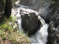
Waterfall Name: Demon Falls
Aka: Ausable, W. Branch The Flume
Location: Wilmington Twn
First Visit: 08-17-2008
State: New York State
Region: Northern Region
County: Essex County
Park Area: ————-
NYS Tourism Region: Adirondack Mountains
NYDEC Region: Eastern Adirondacks/Lake Champlain
Waterfall Challenge: Adirondack Fifty Falls Challenge: A Guide to the Fifty Falls, by John Haywood, Russell Dunn,Essex,pg44
Waterfall Location: N44.36710 W73.83915
Parking: N44.36574 W73.84109
Trailhead: ————-
Trail Name, Reference to: ————-
Stream, River: West Branch Ausable River
Height, Type: 8-10ft,Drops
Elevation: 1037 ft
Level of Difficulty, Hiking Distance: ————-
Whitewater Rte, Canoe Rte Map: https://www.americanwhitewater.org/content/River/detail/id/3465/
Maps: ————-
My Resource: American Whitewater
Book Resource: Adirondack Waterfall Guide: New York’s Cool Cascades Paperback – September 1, 2003, by Russell Dunn,, C. Russell Dunn,II. Falls Along Route 73, Wilmington Notch,pg93
Brochures, Travel Guides, Visitor Guides: ————-
Trail_URL: ————-
Additional Information: Keene Valley Region Waterfall Guide: The Search for Cool Cascades in the Heart of the Adirondacks Paperback – November 10, 2017, by C. Russell Dunn,Section X: Wilmington Notch,pg221
Photos, Information Contributed to other Websites: Dig the Falls
Landmark: Down stream from the Flume Falls
Nearest Intersection: Rte 86 and Rte 63
Directions: From I-87 N in North Hudson, Take exit 30 to the right onto US-9 towards Rt-73/Keene Valley/Keene and drive .2 miles. Turn left onto US 9 and drive 2.2 miles. Keep left onto Hwy 73 N and drive 13.3 miles. Bear right onto Hwy 9n and drive 9.6 miles. Turn left onto Fox Farm Rd and drive .9 miles. Turn right onto Hwy 86 and drive .2 miles.
Comments, Notes: ————-
————-
————-
