
Waterfall Name: Flume Falls, The Wilmington
Aka: Wilmington Falls, Wilmington Flume
Location: Wilmington Twn
First Visit: 08-17-2008
State: New York State
Region: Northern Region
County: Essex County
Park Area: ————-
NYS Tourism Region: Adirondack Mountains
NYDEC Region: Eastern Adirondacks/Lake Champlain
Waterfall Challenge: Adirondack Fifty Falls Challenge: A Guide to the Fifty Falls, by John Haywood, Russell Dunn,Essex,pg44
Waterfall Location: N44.36636 W73.84032
Parking: N44.36739 W73.84026
Trailhead: ————-
Trail Name, Reference to: ————-
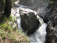
Stream, River: West Branch Ausable River
Height, Type: 50-60ft,Series (Flume Falls-#1 Flume Bridge 10ft,Flume Falls-#2 Split Rock 15-20ft)
Elevation: 1077 ft
Level of Difficulty, Hiking Distance: .2 Miles
Whitewater Rte, Canoe Rte Map: https://www.americanwhitewater.org/content/River/detail/id/3465/
Maps: National Geographic ADK Saranac/Paul Smith Map 2004
My Resource: Eastern New York all outdoors Atlas & Field Guide Publication 2008
Book Resource: Adirondack Waterfall Guide: New York’s Cool Cascades Paperback – September 1, 2003, by Russell Dunn,, C. Russell Dunn,II. Falls Along Route 73, Wilmington Notch,pg93
Brochures, Travel Guides, Visitor Guides: ————-
Trail_URL: https://www.alltrails.com/trail/us/new-york/the-flume-fall
Additional Information: World Waterfall Database
Photos, Information Contributed to other Websites: Dig the Falls
Landmark: Hungry Trout Mtr Inn & Restaurant & Fly
Nearest Intersection: Rte 86 and Rte 63
Directions: From I-87 N in North Hudson, Take exit 30 to the right onto US-9 towards Rt-73/Keene Valley/Keene and drive .2 miles. Turn left onto US 9 and drive 2.2 miles. Keep left onto Hwy 73 N and drive 13.3 miles. Bear right onto Hwy 9n and drive 9.6 miles. Turn left onto Fox Farm Rd and drive .9 miles. Turn right onto Hwy 86 and drive .2 miles.
Comments, Notes: ————-
————-
————-