
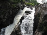
Waterfall Name: High Falls Gorge – Main Falls
Aka: Upper Falls, High Falls
Location: Willmington Twn
First Visit: 08-17-2008
State: New York State
Region: Northern Region
County: Essex County
Park Area: High Falls Gorge
NYS Tourism Region: Adirondack Mountains
NYDEC Region: Eastern Adirondacks/Lake Champlain
Waterfall Challenge: ————-
Waterfall Location: N44.34864 W73.87454
Parking: N44.34724 W73.87731
Trailhead: ————-
Trail Name, Reference to: ————-
Stream, River: West Branch Ausable River
Height, Type: 35ft,Drop,heights varies alot between the different sources
Elevation: 1416 ft
Level of Difficulty, Hiking Distance: The Waterfall Walk is a moderate .5 mile loop, with many stairs. The Easy Path is a .25 mile loop and is handicapp accessible.
Whitewater Rte, Canoe Rte Map: ————-
Maps: ————-
My Resource: Eastern New York all outdoors Atlas and Field Guide Publication 2008,E5,pg95
Book Resource: Adirondack Waterfall Guide: New York’s Cool Cascades Paperback – September 1, 2003, by Russell Dunn,, C. Russell Dunn,II. Falls Along Route 73, Wilmington Notch,pg88
Brochures, Travel Guides, Visitor Guides: Adirondack Great Walks & Day Hikes A Guide To Paths Less Taken In The Northeast’s Last Great Wilderness.
Trail_URL: http://highfallsgorge.com/pdfs/high-falls-gorge-trail-map-wilmington-ny.pdf
Additional Information: Keene Valley Region Waterfall Guide: The Search for Cool Cascades in the Heart of the Adirondacks Paperback – November 10, 2017, by C. Russell Dunn,Section X: Wilmington,pg210
Photos, Information Contributed to other Websites: Dig the Falls
Landmark: ————-
Nearest Intersection: Hwy 86 and Fox Farm Rd
Directions: From I-87 in Westport, Take exit 32 to the right towards Lewis/Willsboro drive for .3 miles. Turn left onto Stowersville Rd and drive for 1.7 miles. Turn left onto US 9 and drive for 5.1 miles. Turn right onto Water St and drive for 1.1 miles. Turn right onto Hwy 9n and drive for 9.3 miles. Turn right onto Hwy 9n and drive for 1.8 miles. Bear right onto Hwy 9n and drive for 9.6 miles. Turn left onto Fox Farm Rd and drive for .9 miles. Turn left onto Hwy 86 and drive for 2.2 miles.
Comments, Notes: From the first overlook upstream is Main Falls and below is Mini Falls
————-
————-
Pingback: High Falls Gorge (4 Named Waterfalls) | Bobbieswaterfalls
Pingback: 12/21/2014 Update | Bobbieswaterfalls