
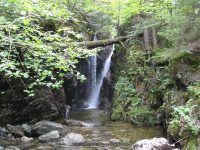
Waterfall Name: St. Huberts-Gill Brook Falls #2 Chute
Aka: St. Huberts-Gill Brook Falls #2, Long Chute like falls
Location: Keene Twn
First Visit: 08-11-2011
State: New York State
Region: Northern Region
County: Essex County
Park Area: Adirondack Mountain Reserve
NYS Tourism Region: Adirondack Mountains
NYDEC Region: Eastern Adirondacks/Lake Champlain
Waterfall Challenge: ————-
Waterfall Location: N44.12397 W73.80948
Parking: N44.14903 W73.77027
Trailhead: N44.14972 W73.78162
Trail Name, Reference to: ————-
Stream, River: Gill Brook
Height, Type: Chute
Elevation: 1918 ft
Level of Difficulty, Hiking Distance: ————-
Whitewater Rte, Canoe Rte Map: ————-
Maps: ————-
My Resource: Adirondack Waterfall Guide: New York’s Cool Cascades Paperback – September 1, 2003, by Russell Dunn,, C. Russell Dunn,II. East Branch of the Ausable River,pg158
Book Resource: ————-
Brochures, Travel Guides, Visitor Guides: ————-
Trail_URL: ————-
Additional Information: ————-
Photos, Information Contributed to other Websites: ————-
Landmark: ————-
Nearest Intersection: ————-
Directions: From I-87 N in North Hudson, Take exit 30 to the right onto US-9 towards Rt-73/Keene Valley/Keene and drive for .2 miles. Turn left onto US 9 and drive for 2.2 miles. Keep left onto Hwy 73 N and drive for 5.4 miles. Turn left onto Ausable Rd and drive for .2 miles to the parking area.
Comments, Notes: (Gill Brook Falls 1 15 ft Block 0.4 N44.12480 W73.80906)(Gill Brook Falls 2 Chute N44.12397 W73.80948)(Gill Brook Falls 4 15 ft Flume N44.12293 W73.80988)(Gill Brook Falls 5 9 ft Cascade N44.12247 W73.81003 )(Gill Brook Falls 6 25 ft N44.12198 W73.81019)(Gill Brook Falls 7 Flume N44.12148 W73.81035)(Gill Brook Falls 8 Long Slide N44.12080 W73.81075)(Gill Brook Falls 9 10 ft N44.11999 W73.81125 )
————-