
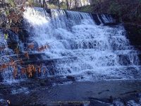
Waterfall Name: Burrville Falls
Aka: Cider Mill Falls, Burrs Mill Falls
Location: Watertown Twn
First Visit: 10-28-2007
State: New York State
Region: Northern Region
County: Jefferson County
Park Area: ————-
NYS Tourism Region: Thousand Island-Seaway
NYDEC Region: Western Adirondacks/Eastern Lake Ontario
Waterfall Challenge: ————-
Waterfall Location: N43.93012 W75.85862
Parking: N43.93055 W75.85931
Trailhead: ————-
Trail Name, Reference to: ————-
Stream, River: Boynton Creek
Height, Type: 30ft
Elevation: 825 ft
Level of Difficulty, Hiking Distance: Roadside view
Whitewater Rte, Canoe Rte Map: ————-
Maps: ————-
My Resource: World Waterfalls Database
Book Resource: Waterfalls of New York State Paperback – August 9, 2012, by Scott Ensminger, David Schryver, Edward Smathers,North Country Region,pg176
Brochures, Travel Guides, Visitor Guides: ————-
Trail_URL: ————-
Additional Information: ————-
Photos, Information Contributed to other Websites: Dig the Falls
Landmark: Burrville Cider Mill
Nearest Intersection: Hwy 12 and Plank Rd
Directions: From the intersection of Rt-126 and Gifford St and Hwy 126 East of Watertown, Get on Gifford St and drive south for 2.7 miles. Turn right onto Plank Rd and drive for .2 miles.
Comments, Notes: ————-
————-
————-
