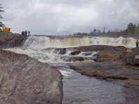
Stream, River: Moose River
Height, Type: 18ft,Block Class III Rapids
Elevation: 1000 ft
Level of Difficulty, Hiking Distance: Easy short walk to the Main Falls and additional .4 mile roundtrip to the Lower Falls.
My Resource: Eastern New York All Outdoors Atlas and Field Guide Publication 2008 pg 114 A3
Book Resource: ————-
Brochures, Travel Guides, Visitor Guides: I Love New York, Adirondacks Tug Hill Region Lewis County Visitor’s Guide
Trail_URL: ————-
Additional Information: ————-
Photos, Information Contributed to other Websites: Dig the Falls, Northern New York Waterfalls
Landmark: ————-
Nearest Intersection: Lyonsdale Rd and Lowdale Rd
Directions: From the intersection of Hwy 12 and Hwy 12d in Lyons Falls, get on McAlpine St and drive northeast for .4 miles.Turn right onto Center St and drive for .5 miles. Turn left onto Laura St and drive for .8 miles. Bear left onto Lyonsdale Rd and drive for 1.5 miles. Turn left into the Agers Falls recreation area. Turn left again and drive down to the end to the lower parking area.
Comments, Notes: From the lower parking area, there is a trail going further downstream. Take this trail for about .2 miles and it will bring you to the Lower Falls. The trail is marked with green paint on the trees. This trail also connects to the trail you would use to access Powerline Falls and Shurform Falls.
Original content here is published under these license terms:
X
License Type:
General Public License
License Abstract:
The GNU General Public License is a free, copyleft license for software and other kinds of works. You may re-publish the content (modified or unmodified) providing the re-publication is itself under the terms of the GPL.