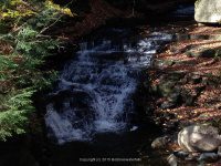
Stream, River: Mill Creek
Height, Type: Step Ledges Various smaller falls
Elevation: 1500 ft
Level of Difficulty, Hiking Distance: Roadside view
Whitewater Rte, Canoe Rte Map: ————-
Maps: ————-
My Resource: Found this simply by being on the wrong road, another drive by.
Book Resource: ————-
Brochures, Travel Guides, Visitor Guides: ————-
Trail_URL: ————-
Additional Information: ————-
Photos, Information Contributed to other Websites: Dig the Falls
Landmark: Gomer Hill
Nearest Intersection: Gomer Hill Rd and Lyman Rd
Directions: From the intersection of Hwy 26 and West Main St, in Turin, drive West on West Main St. At .5 miles you will come to a T intersection of West St and Co Rte 51. Turn left here and then an immediate right onto Gomer Hill Rd. At approximately .4 miles on your left is where we starting taking the photos of the various falls. Some are not significant, and we found the one fair size one. Follow Gomer Hill Rd up to where Mill Creek crosses under the road at the bridge.
Original content here is published under these license terms:
X
License Type:
General Public License
License Abstract:
The GNU General Public License is a free, copyleft license for software and other kinds of works. You may re-publish the content (modified or unmodified) providing the re-publication is itself under the terms of the GPL.


Pingback: Lewis County Waterfall Trip on 6-7-2015 part 2 - Bobbieswaterfalls